Where the
Raindrop Ends
A BARTON SPRINGS DEVOTEE TRACES ITS WATER SOURCE ON A 12-MILE INNER-CITY HIKE
I had long thought Mount Bonnell, Austin’s storied overlook, was the highest point in the city. But this summer, after 17 years of living here, I learned that distinction likely goes to Davis Hill, an 873-foot peak near Brodie and Davis lanes. For a long time, I’ve driven past this spot in Southwest Austin unaware of its status. That’s because I have only known this area as the deepest, not the highest. Hidden just beyond the sidewalks, on both sides of Davis Lane, is a network of caves, one of which reaches all the way down to the water table. Consider the caves a back entrance to Barton Springs Pool—the “soul of our city,” as author James A. Michener once wrote.
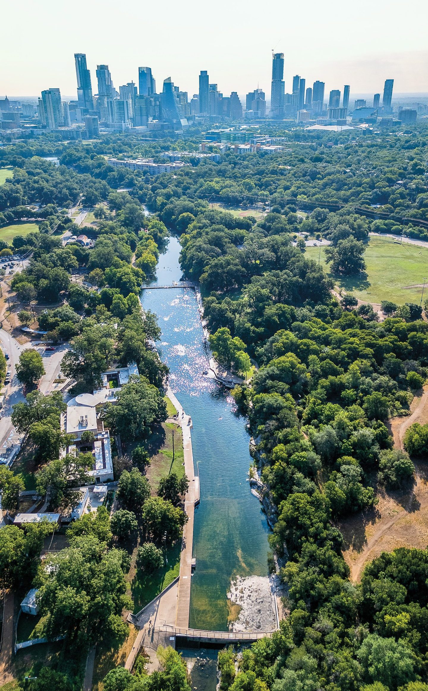
The 1,000-by-145-foot spring-fed pool draws more than 800,000 people every year with its relatively constant 68-degree temperature. It’s “the most visible symbol of Austin’s much-discussed quality of life,” according to Austin Parks and Recreation Department literature. The Oscar-winning actor and director Robert Redford learned to swim in Barton Springs and produced a 2007 documentary, The Unforeseen, about its significance.
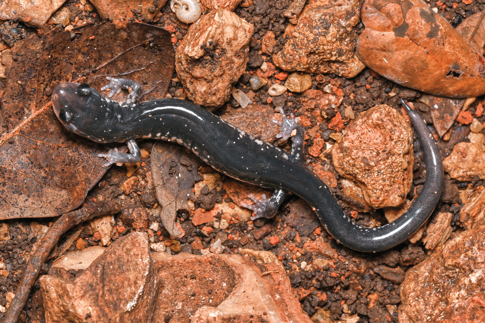
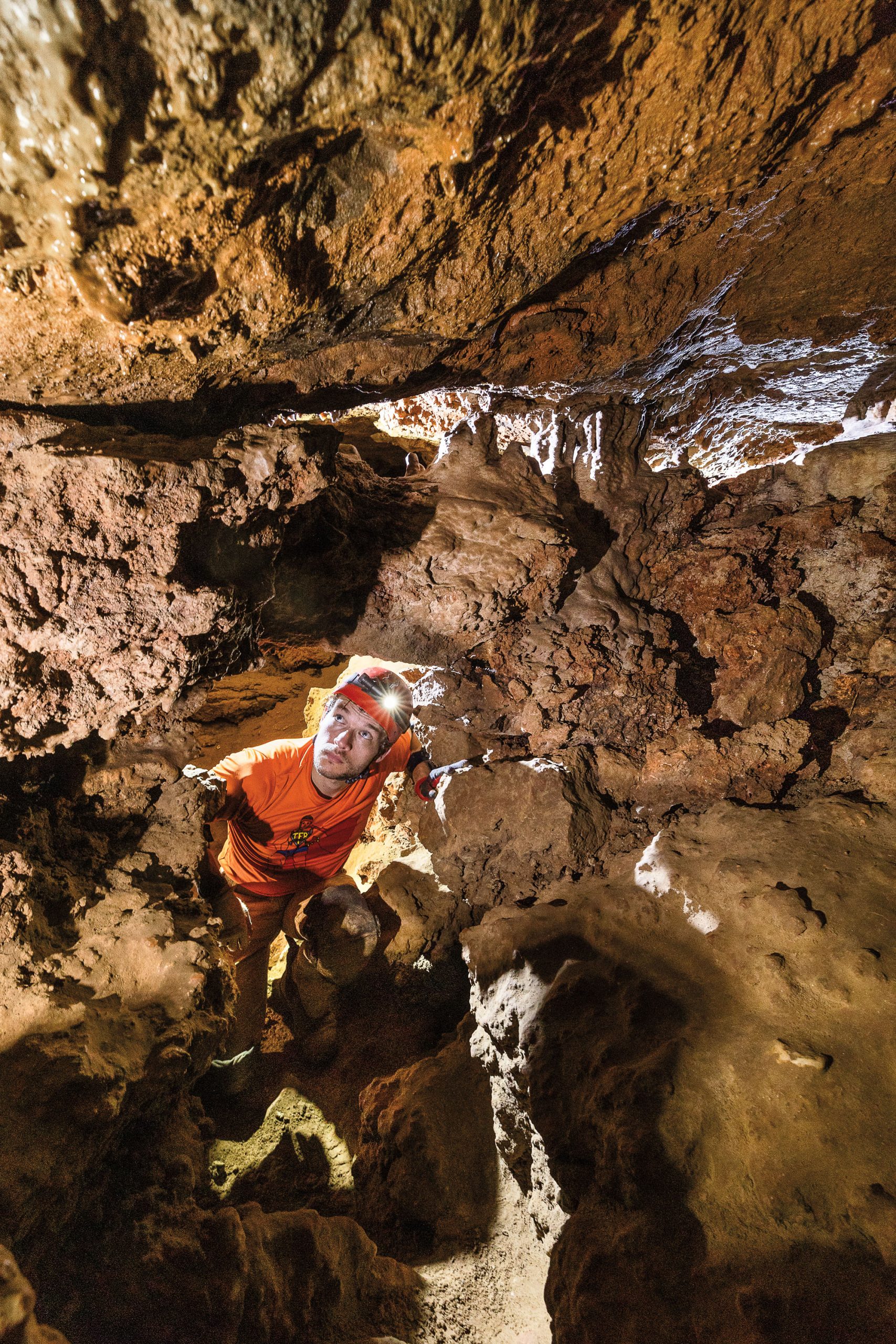
As a regular hiker of the Austin area, I’m mystified by these caves—not just as waterways but as habitats to a host of fragile animals. In 2022, I saw my first western slimy salamander, its purple skin dotted by gold flakes, in Goat Cave. I was like a child seeing the Milky Way for the first time. And across the street, Barton Springs salamanders, once thought only to inhabit Barton Springs, were discovered in Blowing Sink, the deepest cave in Travis County. “It’s the only window into those salamanders’ subterranean range that we have access to,” says Ethan Perrine, a karst biologist and the former president of the Underground Texas Grotto, the oldest caving organization in the state.
With all its apartments and subdivisions, it’s hard to imagine that Davis Lane is also home to a critical recharge zone. Caves here collect rainfall and overflow from creeks and transport water hundreds of feet down to the Barton Springs segment of the Edwards Aquifer, a water source for more than 60,000 people. Groundwater then travels via conduits to issue out as springs—like those at Barton Springs Pool.
A City of Austin Watershed Department kiosk at the Village at Western Oaks Karst Preserve, about 1.5 miles west of Blowing Sink, puts it this way: “If you could shrink down to the size of a raindrop and flow into one of these caves, you’d travel for miles underground and end up at Barton Springs!”
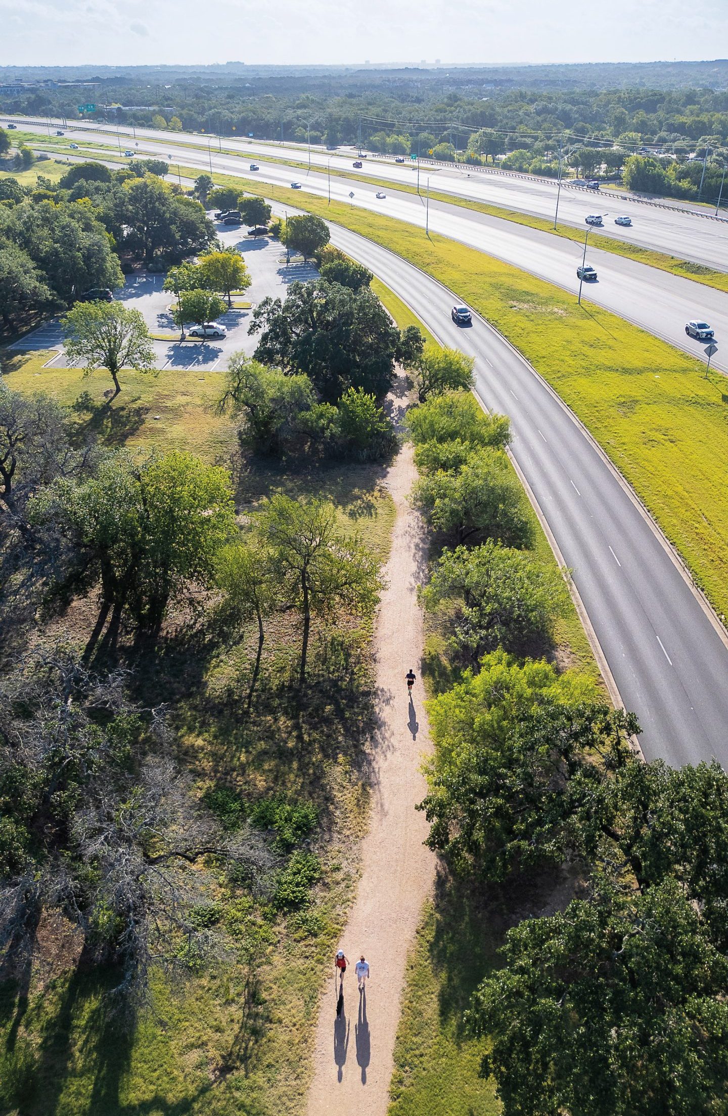
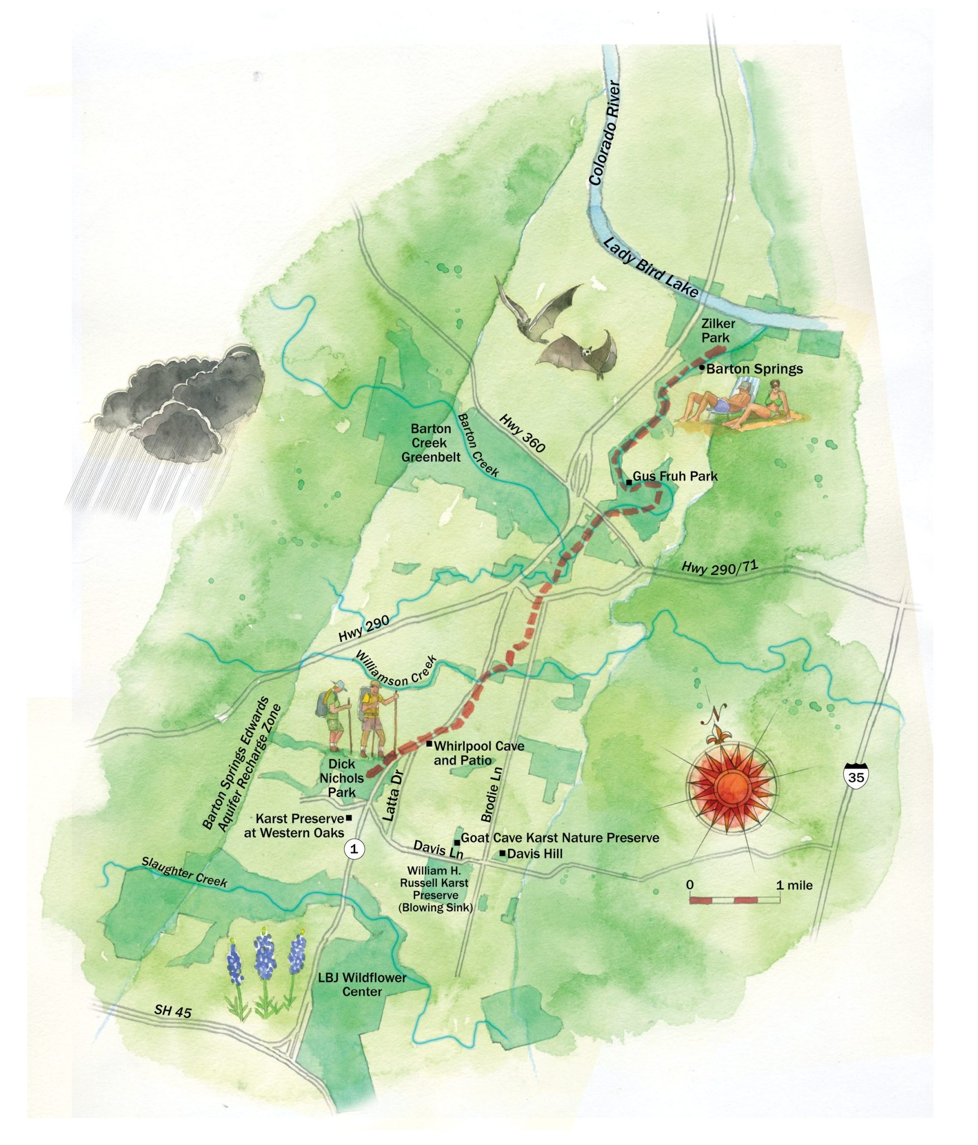
That exclamation inspired me to devise and embark on a publicly accessible, inner-city eco-hike to trace the same path, from the karst preserve on Davis Lane to Barton Springs. It’s an almost 7-mile stretch as the crow flies, but my route would span 12 miles. I wanted to consider the source water of Barton Springs, our aquifer’s connectivity and sensitivity, and cave habitats for seldom seen species. And what better way to end a long hike than with a swim?
It is just after 8 a.m. in late May when Perrine, who is accompanying me on the hike, and I come upon the kiosks at the Village at Western Oaks Karst Preserve. “Water can travel from here to Barton Springs in just a few days,” the text reminds us.
Karst is a type of landscape characterized by sinkholes, caves, and sinking streams formed by the dissolution of bedrock. This creates pathways for rainwater to travel underground and issue out at springs. On this preserve, there are five caves, a creek tributary, and a sinkhole. We’re right next to Equinox Cave.
“This started as just a little 8-inch-diameter hole that was found blowing air by the godfather of Austin-area—and in many ways, Texas—caving, William Russell,” Perrine says. Russell discovered many of the city’s most significant caves, including Blowing Sink in 1984. By day, he worked for the IRS. After his shifts, he was out in the Hill Country, excavating.
Historically, ranchers filled in many area caves to prevent livestock from falling in. Or, they were used as dumps—Perrine tells me of one that had an entire windmill crammed inside. Some sinkholes were plugged to form retention ponds for cattle. But without an opening, there’s no way for a raindrop to get in to recharge the aquifer or to create the moist conditions cave-dwelling creatures need to survive. Last year, the Underground Texas Grotto excavated about 70,000 pounds of rocks, caliche, and trash from various caves as part of its annual restoration activities. “It benefits your wells,” Perrine notes.
We leave the preserve, cross Davis Lane, and enter a back way into Dick Nichols Park. We hike on a trail through a wildflower meadow covered with Indian paintbrush, then cross a concrete track and enter another meadow.
We see a squirrel jump in and out of tall grass, disappearing and reappearing again. I am reminded of how Brian Hunt, a research scientist in the University of Texas at Austin’s Bureau of Economic Geology, describes the path of water to Barton Springs. “The source water, at least in part, originates in the Blanco River,” he says. “It will have multiple ingresses and egresses” going in and out of the ground—just like that squirrel.
We rejoin the concrete track and encounter a sign for the Violet Crown Trail, the first regional trail system in Central Texas for hiking and biking. Currently 13 miles, the path will stretch 30 miles from Barton Springs into Hays County once complete—estimated at 10 to 15 years from now. The project is a partnership between the City of Austin, the City of Sunset Valley, Hays County, the Texas Parks and Wildlife Department, and the Hill Country Conservancy, a nonprofit whose mission is to preserve natural resources by conserving environmentally sensitive land. The trail will join suburban areas of Austin to downtown and provide alternate routes of transportation.
“Water is key for us,” says Carolyn Brennan, senior manager of outreach and engagement for the Hill Country Conservancy. “We try to connect the dots that land conservation is also furthering water conservation. When you’re protecting land, you’re also protecting water.”
I spent over a year conceiving this hike, visiting educational kiosks throughout the city and talking with cavers, biologists, and a hydrogeologist. On one of my scouting trips, I fixated on a map of the Violet Crown Trail. I noticed light shading in baby blue on both sides of the route, indicating water. I realized the trail bisects the boundaries of the Barton Springs Recharge Zone—the area where rainfall and water from the watershed of six creeks go underground. I am now right on top of the path of my hypothetical raindrop.
Perrine and I walk parallel with State Highway Loop 1, known as MoPac Expressway, venturing north—or downstream. A violet pole with a green logo stands in front of us. Numerous trails extending from nearby neighborhoods connect at this main artery—presumably the same way water converges here, underground.
The trail turns into a sidewalk again, and we continue under the overpass onto the east side of the highway. Cars are speeding overhead, tires pelting the bridge’s expansion joints. On the high wall, I notice an engraving of Texas and sapling elms growing out of cracks in the concrete. We’re about 2 miles into our hike when we arrive at Whirlpool Patio, an outdoor classroom for cave and aquifer education.
“A water-loving Austinite should be proud of these signs,” Perrine says. While gazing at educational pieces by local artist Barbara Attwell, he stands on stone tiles decorated with a large swirling emblem—a whirlpool. “I see information about hydrology, ecology, development, and geology,” he says. “And in order to have these maps here, that’s countless hours of work from hundreds of individuals over decades.”
Check the Drip
Hiker Bobby Alemán traced the path of a raindrop flowing
underground through caves along Davis Lane toward
the soul of Austin—Barton Springs.
Just ahead, on the other side of Latta Drive, there’s a parking lot. A path behind the fence leads to Whirlpool Cave, named so because of the way the water drains into the cave under certain flood conditions.
After a short distance, we see a cave entrance covered by a metal cupola gate, which provides access for bats and other wildlife while preventing trespassing. I discovered this opening years ago on a hike with my wife. We peeked in and felt a rush of cool air, as if ghosts were flying out. Then two faces appeared below—cavers Liz and Jef Frank. Liz is the Whirlpool Cave preserve manager, and the pair was making a 3D map of the cave on an iPad.
Years later, I took a tour with them here. On all fours 40 feet down, I crawled through tight spaces called the Corkscrew and the Star Wars Room. We stopped by a wall with a collection of old 8-ounce Coke bottles, tin cans, and lamps that washed in and were uncovered on digs.
Liz shared a story about the cave narrowly avoiding becoming a runoff outlet when MoPac was built. To show that Whirlpool Cave was an environmentally sensitive recharge feature, cavers and environmentalists organized an experiment. They backed up a fire truck to the entrance, ran a hose into the cave, and emptied thousands of gallons of water and a couple of gallons of fluorescein dye, used to track the source of water at its issue points to show environmental impact. The water from Whirlpool Cave arrived at Barton Springs Pool in just days. This led to the relocation of a drainpipe outlet near Whirlpool’s entrance in 1990, preventing swimmers and salamanders downstream from being exposed to polluted stormwater after a rain.
“If the water is coming in dirty,” Liz says, “it’s going to go out dirty.”
Unlike sand aquifers in other states, this portion of the Edwards Aquifer does not filter contaminants. In 1992, Austin voters addressed this vulnerability by passing a watershed ordinance. This was organized by the nonprofit Save Our Springs Alliance, Austin’s water watchdog, to prevent overdevelopment, which increases runoff pollution.
“We owe an eternal debt to Bill Bunch and his then-wife, Helen Ballew, of Save Our Springs,” says George Cofer, founder of the Hill Country Conservancy. “They started that conversation about the aquifer. There were no watershed ordinances, no protection.”
Perrine and I are sitting on a bench at the Arbor Trails shopping center, staring at a retention pond that was the site of a sinkhole collapse on Jan. 24, 2012. That day, 7 million gallons of stormwater escaped into the aquifer. Brian Hunt, who was on-site with the Barton Springs Edwards Aquifer Conservation District at the time, tells me the geo-fabrics that lined the pond had ripped. He said the property owners allowed dye-tracing, and water from the sinkhole was detected at Barton Springs in days.
“You don’t think about Barton Springs when you’re here,” Perrine says.
And yet, runoff over land or surfaces that contain fertilizers, pesticides, oil, antifreeze, sewage, or asphalt sealants can enter the aquifer and contaminate drinking water and springs. As Austin grows, the path of the raindrop is increasingly sensitive to pollution.
I can feel the weight of the sun as we cross MoPac and William Cannon Drive. My feet start to hurt from hours of walking on concrete. We follow a long sidewalk along MoPac’s frontage road and arrive at Ben Garza Lane, close to the former site of Tremenderosa Ranch, purchased by Ben Garza Sr. in 1928.
Garza was a successful butcher in Austin. The ranch was later run by his son, Eli, who discovered Goat Cave in 1945 when Davis Lane was outside the city limits. During a second visit to the cave with friends in 1957, Eli heard a baby goat that had fallen in. After rescuing the goat, he told the American-Statesman there was only one difference on his second visit. Gone were the “innumerable salamanders” from his first visit. A lack of moisture from eight years of drought may explain the absence.
The Violet Crown Trail cuts across the former ranch and passes by the Indian Grass Prairie Preserve, where a red-and-white tower sits in a field of bluebonnets. I notice Perrine begin to pick up trash.
We reach the end of the section and follow Home Depot Boulevard to Brodie Lane. We pass another crosswalk under State Highway 290 and walk the remainder of a crushed granite path. At the 290 Trailhead, we stop to rest by a butterfly garden.
We have traveled about 5 miles. We’re now at 710 feet of elevation—a drop of more than 100 feet from our start at the karst preserve. This section spans the remaining 6 miles of our adventure. We rest for a spell then descend into Gaines Creek Valley, taking on switchbacks, in what might be the prettiest spot in the Barton Creek Greenbelt. Finally, a tree canopy harbors us from the sun, the cars, and the concrete.
We pass a natural rock face for climbing called Beehive Wall. One route is called the Honey Dipper because it tops out at an actual beehive.
After about a mile, we reach a V-gate. I hear the swoosh of cars. We are at the 360 section and have a little over 4 miles to go. Beyond us is a sycamore, or “ghost tree.” This is an indication of groundwater.
Seven miles into our hike, the amount of trash Perrine has collected—mostly plastic wrappers and cups—is too much to carry. We find a trash barrel near the 360 Trailhead and hike back down.
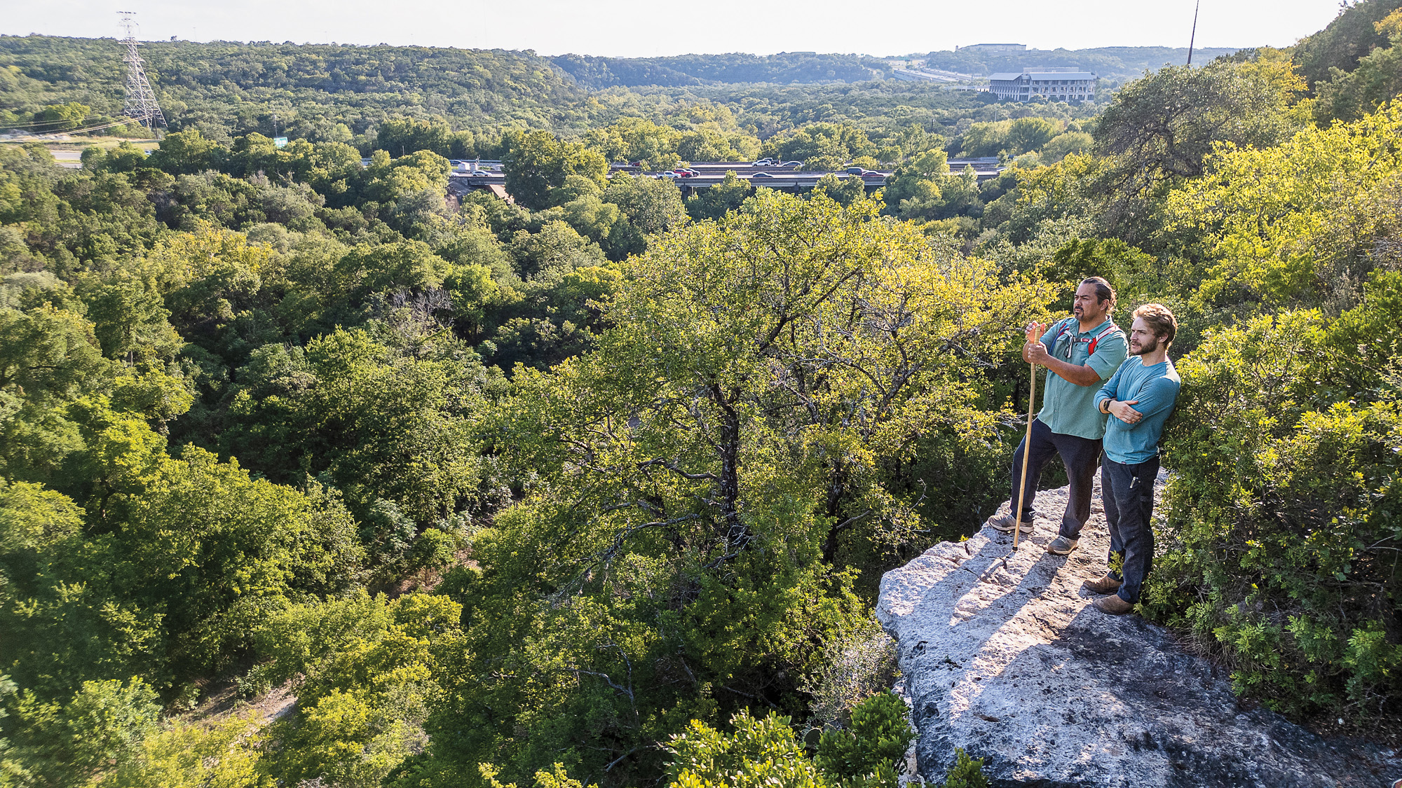
I wrestle with whether to add a mile to our hike for a detour, especially since it’s an incline. But I decide not to pass up an epic view. We cross Seismic Wall, named after an incident where climbers dislodged a large rock and watched it fall to the ground with such massive impact that the sand rippled. We take a left by a grove of live oaks bent over the creekbed like fishing poles with big catches.
We ascend a series of trails to a secret overlook, elevation 616 feet. The ledge is made of sticky fossilized rock that looks like papier-mâché. Even though it feels like we are up high, with traffic below us, we are still lower than the kitchen table at my home in South Austin. I have a delayed epiphany surveying the landscape. I surmise that this water—this raindrop—is being pushed down by gravity to Barton Springs at 435 feet, which is the lowest of all the springs in this region. The hydrogeologist Nico Hauwert confirmed that the flow path from the karst preserve to Barton Springs is unconfined, gravity flow.
We hike back down, beat, and continue north to Horse Shoe Bend, now Gus Fruh Park. The site was renamed on April 27, 1978, to honor the contributions of Gus Fruh, a civil engineering professor at UT Austin. In a resolution by Austin City Council, Fruh was described as “a vital force in Austin’s water quality protection.”
Lauren Scharff, a professor at the Air Force Academy and Fruh’s daughter, recalls family picnics at creeks and catching minnows. “Because he would go out and test water, he knew what streams in the region were clean,” she says.
In a 1971 Austin American-Statesman article, Fruh said, “In Austin, the No. 1 source [of pollution] is urban runoff. This problem has been with Austin a long time.”
When his Distinguished Service Award from the City Council was announced, he was in the hospital with late-stage pancreatic cancer but listened on the radio. He died soon after, at 39.
A rock climbing wall nearby bearing his name is full of ferns—a sign of springs. The wall is known to seep water from its drilled holds.
We don’t have much farther to go. We walk on wide paths near the Spyglass Trailhead, under a tunnel of elms that fills with fireflies at night. I take Perrine across the creek, up a hidden route, and we enter another grove of elm and hackberry trees. We stop by a spring site called Upper Barton Springs. It is dry. We walk to the dam, pushing aside the leaves of a sycamore sapling. Then we walk the last stretch of our 12-mile hike and reach out to touch the south boundary fence of Barton Springs Pool.
I hear multitudes enjoying the water and muse on the interconnectivity of Barton Springs and the caves. I think about what it means to our quality of life—and how this interconnectivity increases threats of contamination. Even worse: Four months after my hike, on Sept. 12, the Barton Springs-Edwards Aquifer Conservation District declared a Stage 3 Exceptional Drought for only the second time in history. Just like my hike, the raindrop does not have an easy path.
Perrine calls it a day, and I walk to my car, grab my towel, and enter the pool. I look down and, in my mind, see silver schools of Mexican tetra shoot across blooming stems of Cabomba. I spot green ribbons of eel grass swaying with the current and Rio Grande cichlids orbiting spring vents. I close my eyes, plunge under, and glide with a few strong kicks.
When I come up, I float on my back and look toward the sky, revitalized. I am reminded of a story Liz Frank, the Whirlpool Cave preserve manager, shared about a fifth grade boy who attended one of her tours and saw a western slimy salamander for the first time. He said he thought the salamander was the night sky. In the same way, I feel like a child making a connection for the first time.