From the canyons to the Coast, explore the many personalities of the fabled river
The Brazos River below Possum Kingdom Lake.
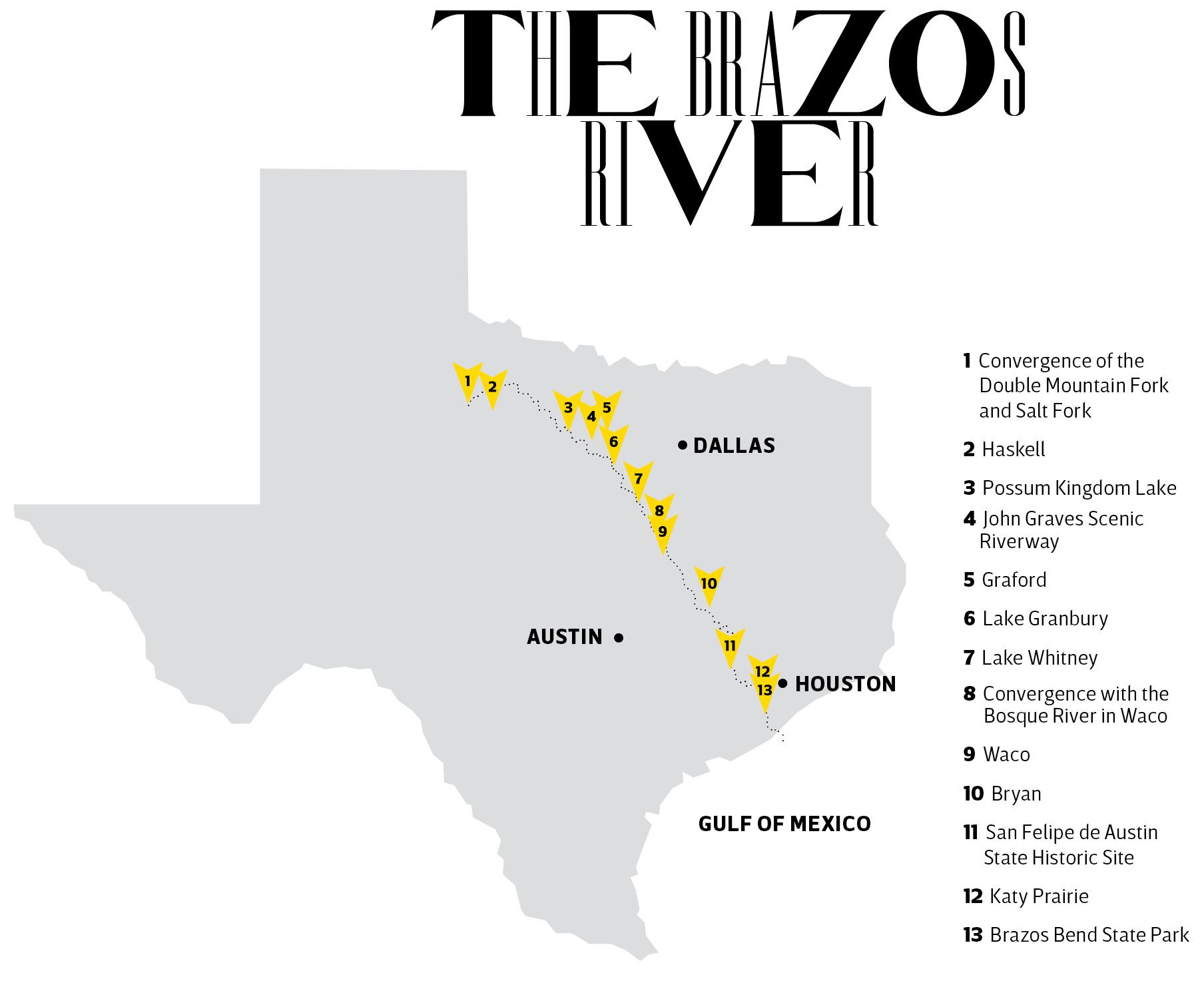
The Brazos
is a river of contradictions. Flowing more than 800 miles on a diagonal course across the breadth of Texas, the Brazos starts as a Western river coming off the High Plains and ends as a Southern river lazily looping its way to the Gulf of Mexico.

Over the course of two centuries, engineers have dammed, channeled, diverted, and fragmented the Brazos, partly to control deadly floods. But while the river has been moderated, it has not been tamed. It still runs wild every now and then, thwarting even the mightiest barriers. As recently as 2016, Brazos River flooding damaged 1,400 homes and killed six people in southeast Texas.
Understanding the Brazos is no easy feat, no matter how many miles you’ve paddled, how many hours you’ve sat on its banks, or how many times you’ve jumped into it. In search of a new perspective, I asked my friend George Farris, owner of Above and Beyond Aviation in Austin, to fly me over the river. On a clear day last fall, Farris took me along as he piloted his Cessna 172 to Haskell, north of Abilene, where we began to trace the Brazos River down to the coast.
With its watershed extending into New Mexico, draws and drainages grow into forks until the Brazos finally becomes a river where the Double Mountain and Salt forks converge in northeast Stonewall County, about 18 miles northwest of Haskell. Here the river carves a ribbon through low, lightly vegetated canyons, its rusty color mirroring the iron oxide-rich red clay soil of the surrounding Rolling Plains.
Seventy air miles east of Haskell, near Graham, the Clear Fork joins the main stem, now a river of substance with distinct bands of dark green vegetation covering its banks and occasional bankside clearings identifying sand-mining operations and crop fields. To the east, wrinkles on the horizon signal the Palo Pinto Mountains and Possum Kingdom Lake, the first major impoundment on the Brazos, dammed in 1941. Covering 17,000 acres, the lake is home to a state park and draws boaters, anglers, skiers, and vacationers.
Below Morris Sheppard Dam, the Brazos courses through tall limestone bluffs and steep cedar-covered slopes. This was Comanche territory 150 years ago, later immortalized in author John Graves’ Goodbye to a River. The book details Graves’ canoe trip with his dog in November 1957, motivated by the coming Lake Granbury impoundment.
“Most autumns, the water is low from the long dry summer, and you have to get out from time to time and wade, leading or dragging your boat through trickling shallows from one pool to the long channel-twisted pool below, hanging up occasionally on shuddering bars of quicksand, making 6 or 8 miles in a day’s lazy work,” Graves wrote, “but if you go to the river at all, you tend not to mind. You are not in a hurry there; you learned long since not to be.”

After flying over the upper Brazos, I made plans to see it up-close with a return in late March to kayak a 19-mile section known as the John Graves Scenic Riverway. My paddling friend David Hollingsworth and I took a shuttle from Rochelle’s Canoe Rental in Graford to the put-in at the State Highway 16 bridge, where fishermen were also gearing up to hit the water, some by kayak and some in a shallow-drafting motorboat.
The land still wore its winter coat thanks to a late spring and extended drought. Amid the pools and riffles, I saw some huge carp and a teeny-tiny minnow. Perhaps it was one of two endangered shiner species that live in the Brazos—the sharpnose shiner and smalleye shiner.
.
Gene Wilde, a biologist who recently retired from Texas Tech University, compares the shiner’s reliance on free-flowing water to salmon of the Northwest. “They need 200 miles of free-flowing river to feed, grow, and spawn, completing their life cycle,” he said. “Dams on the Brazos prevent that.” The minnows were once so abundant that entrepreneurs seine-netted the river to scoop up schools of fish to sell for live bait. Now the little fish are hard to find.
Though the environment is changing, the scenery remains sublime. Long curving bends beneath cuesta slopes provide habitat for countless birds. I spotted over 100 great blue herons flapping their pterodactyl wings, white egrets and hawks by the dozens, and one juvenile golden eagle.
We camped on an island near Chick Bend, between SH 16 and Farm-to-Market Road 4. Hooting owls and howling coyotes serenaded us to sleep. At dawn, three Longhorn cattle awakened us as they lumbered across the island on their way to greener pastures.
Headwinds and low flow—water release from Sheppard Dam was a tepid 100 cubic feet per second—made it a difficult trip, one best saved for better conditions in the spring or fall. But the opportunity to see the same river embraced by Graves and Comanche chief Quanah Parker was worth the effort.

Back in Farris’ Cessna, we followed the Brazos as it wound through low hills before widening into its second major impoundment, Lake Granbury, and about 50 miles later, Lake Whitney. Below Whitney Dam, the Brazos takes on an orderly appearance with houses clustered close to its banks. On the outskirts of Waco, the Bosque River joins the Brazos at the top of the 416-acre Cameron Park, the crown jewel of Waco with its 100-foot limestone cliffs and outdoor recreational opportunities.
Waco is known for its bridges, most of all the Waco Suspension Bridge, the granddaddy of Texas bridges. Constructed with cables made by John Roebling Co., the same contractor who would later build the Brooklyn Bridge, it was the longest single-span bridge west of the Mississippi when it opened in 1870 as a toll bridge. In later decades, the cable system was replaced and the bridge reinforced with steel. The city closed the bridge to vehicles and converted it into a pedestrian bridge in 1971. The 1902 Washington Avenue Bridge, just upstream from the pedestrian bridge, connects downtown to Waco’s east side, a historically Black neighborhood.
Below Interstate 35, the Brazos serves as a scenic backdrop for Baylor University’s football stadium and baseball park, the Mayborn Museum Complex, and the boathouse for the school’s rowing team.
Waco built a new low-water dam in 2007 to mitigate flooding and stabilize Lake Brazos in the downtown area. Todd Nafe, outdoors writer for the Waco Tribune-Herald, said the river has since blossomed as a recreational destination. “The riverfront has become a significant economic resource, with restaurants, parks, food trucks, art festivals, triathlons, fishing tournaments, and fundraising events bringing folks back to the banks,” he said.


Below Waco, the Brazos River runs through the cotton plantation country that seeded the Republic of Texas in the 1800s. As we flew south to refuel in College Station, we watched the Brazos cut through lush woodlands and wide-open prairies. Settlers who were part of Stephen F. Austin’s Old Three Hundred—the first colonists the empresario brought to Texas—developed farms in the Brazos bottomlands, some of them reliant on slave labor before the Civil War.
Robertson County towns like Hearne and Calvert remain primarily African American. Calvert was the hometown of Hall of Fame baseball player Rube Foster, who helped found and operate the National Negro League until his death in 1930. Another notable Foster, singer-songwriter Ruthie Foster—no relation to Rube—grew up in nearby Gause.
“Me and my cousins loved walking or riding in my Papa’s truck down to the river bank all summer long, with our fishing gear in tow,” recalled Foster, who now lives in Austin. “We smaller cousins always made too much noise for the older cousins to catch anything, but it was fun to just hang out, run around with our shoes off, and practice our fishing pole casting.”
To get a closer look at this section of the Brazos, I met six paddlers including Bruce Bodson, executive director of Lower Brazos Riverwatch, on a September morning for a 16-mile kayak trip starting at the SH 21 bridge, southwest of Bryan.
“I call this the free Brazos,” said Bodson, who founded the nonprofit Riverwatch in 2018 to protect the environment of the river’s 425 miles from Waco to the Gulf of Mexico. This is the least appreciated and most industrialized section of the river. “No dams exist below Waco,” he continued. “It is very much a Southern river—slow moving, looping and bending, with a gradient of less than 1%. The water quality is good, just silt-laden. There’s more variability than people realize.”
The river ran wide and muddy along our route, its sandy banks rising 10 to 20 feet high. Black willow, cottonwoods, and sycamores grew along the shorelines, where kingfishers alighted and skimmed the water. We saw three wild hogs swim across the river and a cottonmouth snake futilely chase a large frog out of the water and onto a beach. Along the way, we stopped to examine petrified wood and look for fossilized shark’s teeth and mussel shells.
Lower Brazos Riverwatch reports exposed pipelines and abandoned wells to state authorities, and their stewardship is getting results. “We’ve got legislative committees and landowners paying attention to the river as a potential asset now,” Bodson said.
We finished at the SH 60 bridge, 3 miles southwest of College Station, surrounded by rows of white cotton in every direction. “It’s wilderness down there,” Bodson said. “You get on that river, and there is nobody down there. You are absolutely alone.”
History of the Brazos
By the time 18th-century Spanish explorers gave it the name Los Brazos de Dios (The Arms of God), the Brazos River had been home to creatures and humans for tens of thousands of years. Learn more about this natural and cultural history at museums along the river’s course.
Waco Mammoth National Monument, Waco: About 15,000 years ago, the Brazos was prime habitat for the extinct Columbian mammoth. At this archeological site near the confluence of the Bosque and Brazos rivers, see the fossils of a nursery herd of Ice Age Columbian mammoths, along with fossils of a camel and juvenile saber-toothed cat. nps.gov/waco
Brazos Valley Museum of Natural History, Bryan: This museum features exhibits covering the Brazos Valley’s history back to the Ice Age, including exhibits on Native American artifacts, great Brazos floods, and cotton farming. brazosvalleymuseum.org
San Felipe de Austin State Historic Site, San Felipe: Founded in 1824 on a Brazos River bluff, San Felipe served as Empresario Stephen F. Austin’s colonial capital until it was burned in 1836 during the Runaway Scrape. The historic site includes a museum and replicas of some of the town’s original buildings. thc.texas.gov/historic-sites/san-felipe-de-austin-state-historic-site
Washington-on-the-Brazos State Historic Site, Washington: Along with a living history farm and a museum covering the Texas Republic, this complex contains a replica of Independence Hall—where delegates signed the Texas Declaration of Independence—a riverside exhibit about the historic Robinson Ferry crossing, and exhibits mentioning various 19th-century efforts to navigate the Brazos in steamboats. thc.texas.gov/historic-sites/washington-brazos-state-historic-site
Brazos Bend State Park, Needville: Located 45 miles southwest of Houston, this park has 37 miles of trails to explore wetland lakes and sloughs in the Brazos River bottomlands. The park is known for its alligators and waterfowl. tpwd.texas.gov/state-parks/brazos-bend

From my bird’s-eye view at 5,000 feet, I watched the landscape flatten as the Brazos cruised under US 290 and I-10 and through the Katy Prairie. This landscape looked similar to the Llano Estacado of the Panhandle, except everything was coated a verdant green. About 10 miles from the Gulf of Mexico, the Brazos’ graceful curves and loops straighten into a channel as the river enters Freeport, an industrial maze thick with refineries and tanker ships.
Unlike most Texas rivers, the Brazos empties directly into the Gulf, rather than filtering through bays or estuaries. But it doesn’t meet the ocean where it originally did at Surfside. In 1929, the Army Corps of Engineers diverted the Brazos just upstream by dredging a new channel that empties into the Gulf about 5 miles down the beach.
There, the Brazos ends undramatically. I later drove along the levee road that traces the channel for almost 4 miles, where locals fished for red drum, black drum, trout, and channel cat. After passing a cluster of storage tanks and buildings, I reached a gate with a “No Trespassing” sign. The waves of the Gulf were barely visible in the distance, but I couldn’t go any further.
A mile high up in the air offered a different perspective. Every man-made object I could see—from Possum Kingdom Lake to cotton fields, sand mines, historic bridges, the Houston skyline, and tankers in the Gulf—was tied to that green-brown ribbon I’d been following. As Farris banked his airplane west, I could see the mighty Brazos was really the most Texas river of them all.
Paddle the Brazos
There’s no better way to experience the natural qualities of the Brazos River than from the seat of a kayak or canoe. Outfitters operate at numerous locations on the Brazos, a river that offers a variety of paddling experiences throughout its course.
Rochelle’s Canoe Rental, Graford: provides rentals and shuttles for trips on the upper Brazos’ John Graves Scenic Riverway. rochellescanoeandkayakrental.com
Brazos Outdoor Center, Rainbow: the nearest wild river experience to DFW, includes campsites, equipment rentals, and shuttles. brazosoutdoorcenter.com
Dick’s Canoes, Aquilla: provides rentals and shuttles for trips on the Brazos below Whitney Dam. dickscanoe.com
Pura Vida Paddle, Waco: find kayak and stand-up paddleboard rentals, as well as classes, across the Brazos from Cameron Park and on Lake Waco. puravidapaddle.com
Waco Paddle Company, Waco: canoe, kayak, and stand-up paddleboard rentals in downtown Waco on the bank of the Brazos. wacopaddlecompany.com
Hidalgo Falls, Navasota: The closest whitewater to Houston, this private paddlers park is owned by the Texas Rivers Protection Association. txrivers.org/discover-texas-rivers/brazos-river