Canyon to Canyon
Chasing Panhandle adventure from the Caprock
to Palo Duro to the Canadian River
A view of Palo Duro Canyon from the El Coronado house at Doves Rest Cabins
The mountain bikers of Amarillo
have it better than most. On Thursday evenings, beginners and experts alike gather in Palo Duro Canyon State Park to ride some of Texas’ most thrilling trails. They glide through the canyon bottom, swooping under shady cottonwood trees on the banks of the Prairie Dog Town Fork of the Red River. They rattle across sunbaked rocky draws lined by orange pinnacles. Those wanting to test their legs and lungs climb the park road 600 feet to the canyon rim.
When it starts getting dark, the riders gather near the park entrance at a pavilion on the grounds of a complex of vacation cabins owned by the Shepherd brothers, local cyclists. The fridge is stocked with beer from Amarillo’s Pondaseta Brewing. Bratwurst sizzle on the grill. Stories are told and retold with fresh embellishment.
“One of the main things I love about riding in the canyon is every ride is different, whether you’re riding in the summer when it’s humid and like a jungle or in the wintertime when it’s dry and crisp,” says Richard Douglass, a rider from Amarillo. “I’ve met so many great people through this. The mountain biking community brings people from all walks of life together.”

The Texas Panhandle sometimes gets a bad rap. Drivers speeding through on Interstate 40 or US 87 might dismiss the region as a horizontal expanse of dusty cotton fields, lonesome grain silos, and stinky feedlots. But this is an uninformed perspective, as one look at a topographic map reveals. The Panhandle Plains are certainly vast, but rivers and creeks slash the country like lightning bolts. These drainages pierce the mighty Caprock Escarpment, creating a jumbled shelf over the rolling plains to the east. Millennia of erosion by wind and water have forged a landscape of valleys, breaks, and canyons.
I set out this summer from “downstate”—the locals’ term for the rest of Texas—to explore the Panhandle canyonlands from Caprock Canyons to Palo Duro Canyon to the Canadian River. I discovered not only a vibrant community of local outdoors-lovers, but also a wealth of adventures and distinctive landscapes, all anchored in the rugged history that characterizes the American frontier. Plus, I saw at least one Texas horned lizard on each day of my trip—always a good omen.

Caprock Canyons
We’re driving through the plains south of Quitaque when Chris Podzemny, a local trail-builder and my guide for the day, swerves to a stop at a state historical marker. The plaque recounts the Republic of Texas’ ill-fated Santa Fe Expedition that trudged north through here in 1841 during a failed attempt to claim New Mexico for Texas. Disoriented, hungry, and peppered by Kiowa attacks, the expedition made camp nearby at the juncture of Quitaque and Los Lingos creeks.
It’s easy to imagine getting lost among the swells and valleys that approach the caprock, but today we have a clear destination—the Caprock Canyons Trailway, a 65-mile route that follows an old railroad bed between the towns of Estelline and South Plains. The railroad opened in 1928, hauling commodities like cattle, cotton, and gravel across the Panhandle. The line closed in 1989, and by 1994, the Texas Parks and Wildlife Department had converted it into a trail. While Caprock Canyons State Park and Trailway is best known for its 300-head bison herd, prairie dog towns, and hiking trails that navigate 1,000 feet of elevation from the top of the Caprock Escarpment to the Little Red River, we’ve brought bikes for a moderate 21-mile, out-and-back route starting at Monk’s Crossing.
Pedaling along a section of trail that’s mostly flat and surfaced with crushed rock and packed dirt, I dodge a parade of grasshoppers, six-lined racerunner lizards, and a couple of horny toads—all fat and happy with the unusually wet summer.
The star of this section of trail is the Clarity Tunnel, a 725-foot railroad shaft through a rocky hill. A colony of a half-million Mexican free-tailed bats has taken up summer residence in the tunnel. It’s not necessarily for the squeamish, but riding a bike through the dark corridor—navigating a thin track through foot-deep guano with the chirping of bats overhead amid an intense odor of ammonia—makes for a memorable adventure.
The payoff is spectacular scenery. As the trail follows Quitaque Creek and climbs in elevation, numerous bridges cross the gravel stream, giving overhead views of clear waters trickling through red-rock ravines and sandy banks thick with cottonwoods and wild plums. Overhead, Mississippi kites soar against a backdrop of billowing cumulous clouds.
“It’s a pretty hardcore trail—not a Disney ride for sure,” Donald Beard, the superintendent of Caprock Canyons State Park and Trailway, tells me later in reference to the full 65-mile route. “You’re on your own. Cell phone service may or may not work. But for a lot of people, it’s a challenge they want to conquer.”

Palo Duro Canyon
Given the pivotal role of horses in Panhandle history, horseback rides provide a fitting perspective of Palo Duro Canyon, the region’s signature natural attraction. The Spanish introduced horses to Texas in the 16th century: Francisco Coronado first traversed the Panhandle, including the canyon, in 1541. Plains tribes including the Kiowa, Apache, and Comanche quickly seized on the animals’ potential, evolving into master horsemen as warriors and hunters. The U.S. Cavalry subsequently fought the tribes on horseback and targeted the tribes’ remudas, a ruthlessly effective tactic on full display at the Battle of Palo Duro in 1874, a decisive defeat for the Comanches. The battle helped clear the way for sprawling cattle ranches built by cowboys like Charles Goodnight, forever linked with horses in Texas legend.
“Palo Duro Canyon and the surrounding area was the last free home of the most powerful Indian tribe in American history—the Comanches,” says Phyllis Golden, owner of Cowgirls and Cowboys in the West, which guides horseback rides on Los Cedros Ranch near Amarillo. “This was their winter home. When you get to the rim of the canyon, you’ll see the protection from the wind and weather in the canyon. And there’s water down there, which is very rare here.”
On our ride, Golden’s American quarter horses amble out across the open prairie, stepping around mesquite trees and prickly pear cactus. Spotting movement in the thick grass, a wrangler pounces from her horse and snatches a horny toad from the brush to show the riders. Soon, the land starts buckling into shallow draws before abruptly giving way to the massive chasm of Palo Duro Canyon. We stop for pictures against a backdrop of big sky sliced in half by the opposite canyon rim and its walls of banded orange, pink, and green.
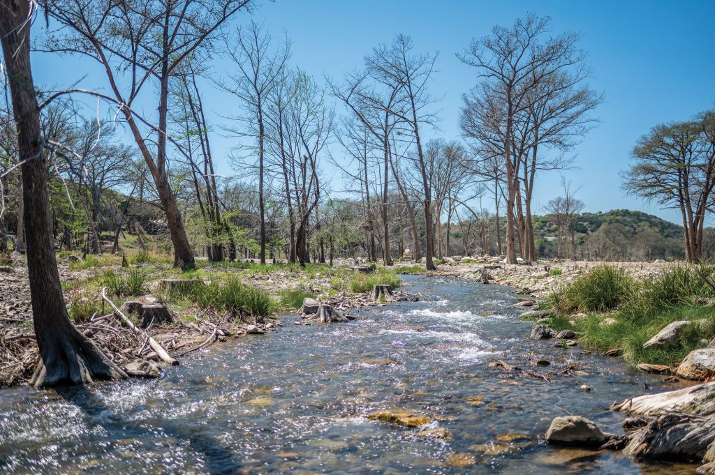
Later, in a visit to Palo Duro Canyon State Park, I walk along the Prairie Dog Town Fork of the Red River, which is flowing swiftly from summer rains. I try to picture how this narrow stream could carve a canyon 800 feet deep, 120 miles long, and 12 miles wide. On a hike up the canyon walls on the Rock Garden Trail, I reach a point on the Tub Springs Draw Spur—named for an old cowboy bathing spot—where a shallow slot canyon opens to a dry pouroff over a massive box canyon. I shimmy out on my stomach to crane my neck over the ledge for a head-spinning look at a shimmering pool far below.
“When you start to think of this place in terms of edges, it covers so many different aspects,” says Jeff Davis, Palo Duro assistant park superintendent. “We’re in this liminal space where the flats of the High Plains turn into the Rolling Plains at the Caprock Escarpment. We are at a juncture between different migratory paths of birds. And this canyon was the site of the Battle of Palo Duro, which was the edges of two cultures really clashing with each other and the end of a way of life for one of those cultures.”


Canadian River Valley
A fascinating phenomenon unfolds when approaching the Canadian River from State Highway 136 at Alibates Flint Quarries National Monument. Just as the park road begins to descend into the valley, a massive view opens of the river channel splitting the valley before flowing into the blue water of Lake Meredith. The river water, hued a burnt orange from the surrounding rocks, meets the lake, creating a vibrant borderline of orange and blue that fades as the waters blend and give way to the lake’s ultramarine depths.
The scene is a precursor of the colorful Alibates flint rock I’ve come to see. President Lyndon B. Johnson created this national monument in the 1960s to protect the ancient quarries located above the river valley when the Canadian River was dammed to create Lake Meredith for water supply and recreation. Archeologists have discovered evidence of a succession of indigenous cultures living here as long as 13,000 years ago. The monument includes the remains of a village of the Antelope Creek people, who lived above the valley from roughly A.D. 1150 to 1450, as well as more than 700 flint quarries. Dug from the dolomite caprock, the quarries are shallow depressions each about the diameter of a tetherball court.
Alibates flint—which was named in the early 1900s for a local cowboy named Allen Bates—occurs in about a 10-square-mile area, explains Park Ranger Kenny Points, during one of the daily hiking tours to see the quarries. Long ago, the natives figured out the flint could be shaped using stone hammers into hard, sharp blades for spear points, drills, scrapers, and arrowheads. Tools made from Alibates flint have been found as far afield as Mexico, Montana, and the Mississippi River. Conversely, archeologists have found far-flung artifacts here, including pipe stone from Minnesota, obsidian from New Mexico, and seashells from the Pacific Ocean.
“It’s just really amazing for rock to travel from Minnesota to here before there’s an automobile or even a horse to bring it here, and for this rock to travel all the way from here to the Great Lakes,” Points says.
In October, when the weather is cooler and in recognition of Texas Archeology Month, park rangers lead Saturday tours of the Antelope Creek village site, which is located a mile from the quarries themselves. “It was about a mile walk to work for them,” Points says. “We think that happened because the flint was being traded so heavily that they didn’t want to show anybody the exact location of the quarries.”
The caution of the Antelope Creek people makes perfect sense. But after exploring the Panhandle’s canyonlands and the scenic adventures around them, I see no reason to keep these Texas treasures a secret.