W.D. Smithers, Courtesy Museum of the Big Bend, Sul Ross State University
The Big Bend’s desert mountains are like magnets for modern nomads seeking isolation and adventure. But the region’s wide-open wilderness hasn’t always been valued as a haven for escape and personal renewal. The promise of mineral riches beneath the rocky remoteness pulled prospectors of the past. These opportunists weren’t looking to get away from it all—they wanted to fill their pockets.
From about 1900 to 1950, the Big Bend region was one of America’s top producers of mercury, also known as quicksilver, an element extracted from cinnabar ore that was once a key ingredient in detonators. About a dozen mines operated in the Terlingua Quicksilver District, which covered parts of Presidio and Brewster counties. Mining companies dug shafts hundreds of feet deep and lugged out cinnabar by hand, cart, and burro. Furnaces heated the scarlet-red rock to release mercury vapor, which was condensed into liquid metal and bottled in cast-iron flasks. Railroads shipped the flasks around the globe as World Wars I and II drove demand for quicksilver to make ammunition and explosives, as well as thermometers.
These days, remnants of the quicksilver era crop up across the Big Bend’s arid expanses in the form of abandoned towns, mine ruins scattered with defunct equipment, rocky freight-wagon trails, and interpretive exhibits that explore the bygone era. An exploration of Big Bend mining history not only traverses some of Texas’ most scenic terrain, it also illuminates how the quicksilver era helped shape the region as we know it, from infrastructure to local culture and tourism.

Saint Agnus Church in Terlingua.
Terlingua
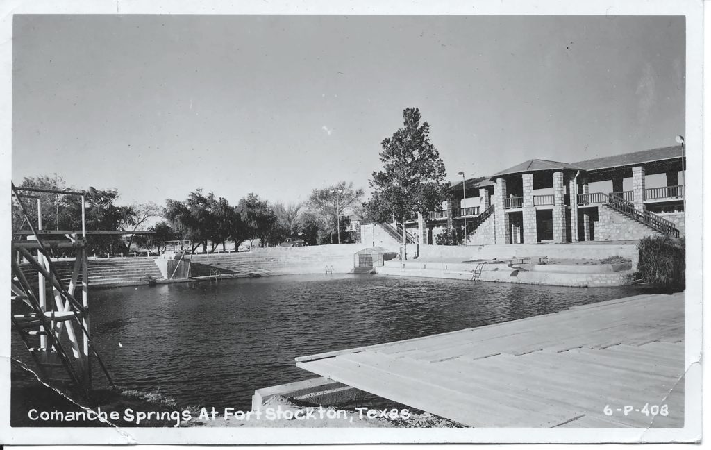
Mining heritage is nowhere more tangible than in Terlingua, an outpost about 8 miles from the border of Big Bend National Park. Terlingua Ghost Town, as it’s now known, inhabits the skeleton of the 1903 Chisos Mining Company. Chicago industrialist Howard Perry opened the mine after discovering that land he received as payment for a debt happened to sit atop rich cinnabar deposits. (According to one legend, the ore was so prevalent that a cowboy observed drops of quicksilver form on the ground from the heat of a branding fire.)
The Chisos Mine turned out to be the biggest mercury producer in the region, and at times, in the nation. In the town’s heyday of the 1910s and ’20s, as many as 2,000 people lived in Terlingua, which had a post office, company store, hotel, school, and dance pavilion. Most of the residents were Mexicans who had moved north to escape the violence of the Mexican Revolution and oppressive working conditions in Mexican mines. Finding work in Terlingua, they built simple homes of stacked limestone rocks and adobe mortar.
The ruins of these structures squat among the creosote and cactus bushes on the Terlingua hillside and give the town its rustic architectural style. Some of the ruins sit in crumbling disrepair, but in recent decades, locals have restored and expanded many of the old homes. The surviving stone masonry serves as the foundation for residences, vacation lodgings, galleries, and the go-to spot for breakfast burritos and coffee—Espresso y Poco Mas.
“That someone was enterprising enough to begin a fairly major industrial development in the area borders on the miraculous,” Kenneth Ragsdale in Quicksilver.
Ninety-three-year-old Maria Bermudez was born and raised in Terlingua, the daughter of Mexican immigrants who married in the mining town. Now a resident of Alpine, about 80 miles north, Maria remembers her Terlingua childhood as a happy and safe time, though demanding. She helped carry buckets of water from the town’s central storage tank to her family’s home. And after her father died, she balanced school with daily work as a housekeeper at the Chisos Hotel, which has since burned down. Maria smiles at the memories of Saturday-night dances and the comfort of sleeping outside on temperate desert nights—a custom still common among Terlingua residents today.
“Everybody was real happy there,” says Maria, thumbing through a folder of black-and-white photos of her family and old Terlingua. “I hear so many say, ‘If they didn’t close the mines, I would still live in Terlingua.’ And it’s true. If they didn’t close those mines, we’d still live there.”

The Starlight Theatre eatery occupies the Chisos Mining Company’s 1939 cinema house.
Nowadays Terlingua is most famous for its two chili cookoffs held each November and for the live-and-let-live ethos of the independent spirits who call the area home—a mix of outdoorsmen, artists, mystics, and end-of-the-liners. It’s also a popular overnight stop for travelers visiting Big Bend National Park.
“In Terlingua, mañana doesn’t mean tomorrow—it just means not today,” jokes lifelong Big Bend resident Bill Ivey, who bought the old mining town in 1982 and has worked to preserve its history and develop tourism. Ivey grew up in nearby Lajitas working at his family’s trading post. In Terlingua, he has restored some of the old adobe-brick residences of Chisos Mining Company officials as accommodations, including the foreman’s house, the mechanic’s house, and Perry’s 1906 home, known as the Perry Mansion, which is currently under renovation. Perry built the two-story home like a fortress, including an underground escape tunnel because of his unrealized fear that bandits or revolutionary insurgents from Mexico would raid the town.
“Terlingua is the only place in the world I know of where people sit and watch the sun go down in the east,” Ivey adds, referring to Terlingua’s uninhibited view of the Chisos Mountains, an outcropping on the eastern horizon that transforms in the sunrays of dusk from desert camouflage into a ridge of glowing orange and pink. Locals and tourists gather to watch the spectacle from the Terlingua Trading Company’s front porch, a meeting place for guitar-picking and beer-drinking.
The Trading Company, a gift shop with a trove of regional souvenirs, books, and artwork, occupies the old Chisos Store, a mercantile from the mining days. Next door, the Starlight Theatre, a restaurant, bar, and live-music venue, has taken over the building that once housed a cinema for mine employees. Despite Terlingua’s isolation, crowds show up most any given night for the Starlight’s draft beer and entrées like chicken-fried wild boar.

Big Bend Stables’ horse-back tour in Study Butte.
For an introduction to Terlingua’s mining history, the Trading Company sells walking-tour maps ($1) that cover numerous sites around the ghost town. Stops include the Terlingua Cemetery, a picturesque burial ground that’s a popular spot for Day of the Dead memorials in the fall; and the abandoned mineshafts, which are the only industrial remnant of the mining era. Structures such as furnace buildings and head frames were salvaged for scrap after the mine closed.
Visitors can step onto the iron grates covering the mine shafts, peer into the dark abyss, and feel the rising draft of warm, moist air. By the time the Chisos Mine closed in 1945, there were some 23 miles of subsurface workings stretching out from several shafts. The dark and humid tunnels were always dangerous places. Most injuries and deaths at the Chisos Mine resulted from accidents related to falls and equipment, the late historian Kenneth Ragsdale recounted in his book, Quicksilver: Terlingua and the Chisos Mining Company. There were no documented cases of mercury poisoning, although Ragsdale reported that some employees who inhaled the toxic fumes of the quicksilver furnace suffered from salivation, a condition in which the salivary glands produced excessive spit—to the point that the afflicteds’ teeth fell out.
Far Afield
Considering the distance separating the cinnabar mines from medical services in Alpine, an otherwise treatable injury could be fatal during the mining days. Even now, you’d be in trouble if you suffered a serious injury at the abandoned Mariscal Mine. Located about 30 miles southeast of Terlingua in Big Bend National Park, the mine seems to have been dropped from the sky onto the slope of Mariscal Mountain. Branching off from Route 12, the 20-mile drive on River Road East to the Mariscal Mine is slow but scenic as the road traverses dry arroyos, flats of sunbaked bentonite clay, and sandstone bluffs streaked with calcite veins.
A sign at the Mariscal Mine’s parking lot trailhead provides a brief history of the operation, which lasted from 1906 to 1944. Lined by lechuguilla and cholla cactus, the gravel trail up to the mine first passes the crumbling, roofless remnants of the miners’ homes, similar to the ruins at Terlingua.
“It’s an interesting contrast,” notes Mike Davidson, who leads customized tours through his guiding company, Big Bend Texas Travel Company. “You go to Terlingua, and it’s populated and everything has been repurposed. And then here there’s nothing—it’s completely untouched.”
Above the mine ruins, which include a crumbling brick furnace, condensers, a processing building, and tailings piles (rock shards left over from the processing of the cinnabar ore), the trail summits Mariscal Mountain. Shimmering views stretch out like quicksilver pools butting up against distant ranges such as Coahuila’s Sierra del Carmen, a sheer ridge of pink with stripes of gray rock and green pine forest.
From that Mexican range, the Puerto Rico Mine extracted lead, zinc, and silver starting in the 1890s (and still operates today). In 1910, the mine built a 6-mile tramway across the Rio Grande to present-day Big Bend National Park, where the ore was unloaded and freighted by mule-drawn cart to the railroad in Marathon, says Tom Alex, a retired national park archeologist and co-author of the local history book Around Terlingua. Today, boaters on the Rio Grande can see the ruins of the tramway towers’ concrete footings on the riverbank, and the popular Old Ore Road through the Big Bend backcountry follows part of the historic freight route up to Marathon.
Essentials
For Big Bend travel information, visit the Brewster County Tourism Council’s Visit Big Bend website.
Terlingua is 5 miles west of Study Butte on FM 170. For Ghost Town travel and lodging information, call Big Bend Holiday Hotel at 432-203-6929.
Big Bend Stables is just south of the junction of Texas 118 and FM 170 in Study Butte. Call 800-887-4331.
Big Bend Texas Travel Company leads customized tours throughout the region, including trips focused on mining history. Call 432-386-5635.
The Mariscal Mine is in Big Bend National Park, 20 miles off the main park road on River Road East. River Road is gravel; high-clearance vehicles are required. It’s a short hike from the parking lot to the mine ruins. Call 432-477-2251.
The Whit-Roy Mine and Buena Suerte village are in Big Bend Ranch State Park, an 8-mile hike from East Contrabando Trailhead, located on FM 170 near the Barton Warnock Visitor Center. Call 432-424-3327.
Prior to the arrival of automobiles in the 1930s, freighters driving large wagons pulled by teams of eight to 12 mules connected the cinnabar mines to trading posts and rail yards in Marfa, Alpine, and Marathon. It took at least two days to make the dusty, bone-rattling trip to the railroad towns.
“The freight wagons would haul the processed mercury up, and then they would load up with goods to bring back to the community,” Alex says. “Even today people down here have a different attitude and idea about driving distances. And it’s common to ask around and pick up odds and ends for several different people when you do your town trips.”
You can get an idea of what it was like to travel around the Big Bend at the turn of the 20th century in Study Butte (about 5 miles east of Terlingua), where Big Bend Stables offers horseback tours that crisscross a cinnabar mine that operated intermittently from about 1903 to 1972. As the trail climbs a mesa and then crosses gravelly Rough Run Creek, guides point out remnants like the roofless assay office, where the mercury was weighed and valued, pink tailings piles, rusty iron cables, and an earthen mound where the mine stored its dynamite.
West of Terlingua in Big Bend Ranch State Park, hikers and mountain bikers on the Buena Suerte Trail follow part of the historic Marfa-Terlingua Road—the original lifeline from the mines to civilization—through boulder-strewn mesas and hard-packed hills sprouting ocotillo, whitethorn acacia, and Torrey yucca. From the East Contrabando Trailhead, it’s an 8-mile hike to Fresno Canyon and the ruins of the Whit-Roy and Fresno quicksilver mines, as well as the old Buena Suerte town site.

A mining shaft at Whit-Roy Mine in Big Bend Ranch State Park.
At the Whit-Roy Mine, the steel, concrete, and rubber of an old rock crusher, hopper, furnace, and conveyor belt convey the mine’s industrial nature, minus the constant noise that would have accompanied such an operation. Steps away, the ghost town of Buena Suerte retains the abandoned buildings of a 1940s mercantile and school as well as a striking collection of row houses. Meticulously crafted with stacked limestone rocks and adobe mortar, the now-roofless rows squat on inclines of gravel and brush, decomposing congruously with their desert surroundings.
Mercury mining cycled through booms and busts in the first half of the 20th century until the market dried up. After World War II, few mining companies mustered the optimism to keep digging in the face of low prices, competition from foreign mines, and the challenges of operating in the Big Bend. Backers of last-ditch efforts in the late 1960s at Fresno and Study Butte had walked away by 1973.
Memories of the quicksilver era live on, however, in Big Bend natives like Maria Bermudez and in newcomers looking to test themselves in the region’s spectacular yet demanding environment—just as their mining forebears before them. “Everybody is always looking for the last best place,” Ivey says. “And really and truly, this is part of the last frontier. It’s where you can do what you want to do, be what you want to be.”

Illustration by Stephanie Dalton
Senior Editor Matt Joyce and Photo Editor Brandon Jakobeit’s January 2017 research trip for this story coincided with a blue northern that brought blustery winds and 13-degree temperatures.