Braving the Narrows
An avid hiker embarks on a ‘water walk’
to explore one of Texas' most mythic oases
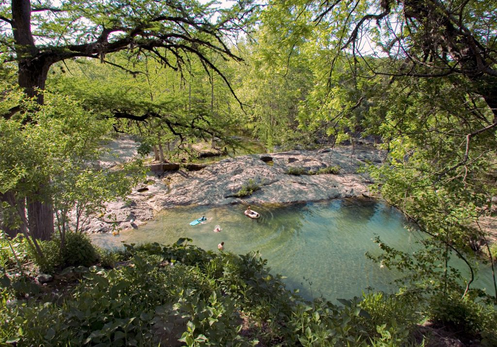
The author maneuvers the narrows

In
a field of brickellbush, hundreds of monarch
butterflies move with the grace of a Disney fairy waving a wand. They circle back and forth in figure eights all around us, flashing black and orange wings dotted with white, as they fly from stem to stem undisturbed. My guide, Jim, and I take off our hats while my wife, Vanessa, takes out her camera. We stand there, spellbound.

It’s only later that I realize the scene was likely a once-in-a-lifetime experience. But maybe our whole trip was. We were there last October to find a place called the Narrows. This limestone gorge on the Blanco River has hidden, almost tropical pools where honeycombed rock walls, skirted with maidenhair fern, shimmer with the water’s reflection—a Texas oasis like no other. After hearing about the Narrows several years ago and finding pictures online, I dreamt about seeing it for real. But there was another reason for my interest. I had just learned about Josephine Mandamin, an Anishinaabekwe First Nation woman who had popularized the concept of a “water walk.” Undertaken in Canada 20 years ago, hers was an act of defiance against those polluting her community’s water. I felt compelled to commemorate the anniversary of her noble effort.
A water walk is just that: a mindful walk by water. While some consider it an act of resistance or even a spiritual exercise—a feat of reverence to our most precious resource—others approach it as a journey to trace water’s route from sea to source to better understand how it makes its way to our drinking taps. For most of my life, I’ve only ever thought about water in terms of its absence—drought and the aftereffects. I intended to learn more about where it comes from and how it’s threatened.
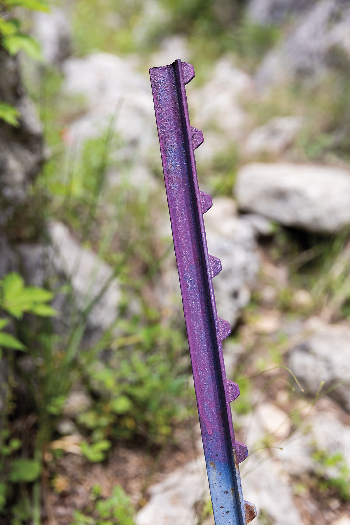
A t-post marks a private property line
“Water is the one substance without which no plant or animal can survive,” says Andrew Sansom, founder of The Meadows Center for Water and the Environment, a research and education center for water issues at Texas State University. “It’s essential to all of life. And if we deplete it, we’re going to be in a world of hurt—and we’re on the way to doing that.”
To many hikers in Texas, the Narrows is the Holy Grail, hidden somewhere on the Blanco between the triangle of Henly, Blanco, and Fischer. The trip offers hikers the two things they always pursue: a challenging hike and the promise of an unparalleled view. The gorge, about a quarter-mile long, looks like a place where the earth has split open, with bedrock pulled apart to reveal spring-fed pools.
Ask anyone in the hiking community about getting there and you’ll hear these refrains: It’s hardly accessible, fiercely guarded, and a punishing march even on a good day. The hike is 14 miles with water crossings. There is little to no cell service. No trails. No map. And—here’s the biggie—you probably aren’t welcome there. Landowners stay on the lookout for anyone stepping foot on private land. Watch for purple paint sprayed on rocks or brushed on fence posts as a warning and boundary line.
A friend of mine, who tried to hike it in the summer of 2022, went the wrong way and returned to her car to find every one of her stem valves ripped out. All her tires were flat. After hours of trying to get a tow truck, three nearby residents helped get her back on the road, visiting with her afterward over beers. She shared all the stories she’d heard about unfriendly locals and listened as they told her most weren’t that way. But they admitted some believe visitors don’t respect the land.
That’s why Vanessa, my constant hiking companion, and I weren’t going to hike it alone. We wanted to go with someone who had done it before. We chose the fall to avoid the heat. Our chaperone for the trip was Jim Wigginton, a software developer and amateur drone photographer from Austin. He had made the trek himself once before, alone.
In 2000, Josephine, an Anishinaabekwe grandmother from Thunder Bay, Ontario, attended a Three Fires Sun Dance in Pipestone, Minnesota. She listened as a wise ogimaa, the Grand Chief Eddie Benton-Benai, issued a warning to all those gathered. He told them that in 30 years an ounce of water is going to cost as much as an ounce of gold, according to published interviews with Josephine.
Josephine felt like he was talking to her. In her culture, women were considered protectors of the water. The chief looked out on the crowd and asked them, “What are you going to do about it?” Three years passed before Josephine, along with seven other grandmothers, pledged to do something incredible in response. On Easter Monday, they set off to walk the 1,300 miles around the entirety of Lake Superior as a prayer ceremony of reconnection and devotion to the water.
Josephine started in Wisconsin. She was in her 60s and had a limp, but she shuffled with a fast pace around the lake while carrying a copper pail of water weighing 30 pounds. The pail was a symbol of their prayers, good intentions, and responsibility to the water.
“The more you spend time with that water and care for that water, you start to get an understanding of what that water is going through,” says Regina Mandamin, the daughter of Josephine, who died in 2019.
Josephine wore long, colorful skirts and boxy tennis shoes and could be heard singing or praying just under her breath. She held an eagle staff with feathers in one hand. She carried semaa, sacred tobacco, that she and the other grandmothers presented to the water as an offering. This journey was the first Mother Earth Water Walk, as two Canadian newspapers referred to it, of many for the group of women. Rising before dawn, they averaged 30 miles a day.
“Every step is a prayer,” says Fort William First Nation elder Sheila DeCorte, who partook in Josephine’s last walk, a 3,197-mile trek over 97 days in 2017. “It’s to bring healing to the water so that we will not only have water for our generation, but future generations to come.”


The only water I carry to the Narrows is inside my CamelBak. It weighs a mere 8 pounds. And the only staff I hold in my hand is a hiking stick I purchased at Lost Maples. I don’t sing on the way, but I do pray. For the first time I can remember, I am thinking about water in a real way. Instead of believing drought is the reason Texas waterways are dry, I start to question whether other factors are at play.
It’s a little after 2 p.m., about 5 miles in, when we encounter our first deep-water crossing. In chest-high water, we go from tiptoeing on uneven rocks to sinking in sand, often knocking our knees against unseen boulders underwater. I grimace and notice the cliffs around me changing from linear faces and edges to bulbous shapes. At the top of the cliffs are rows of bare sotol stalks. Occasionally, a butterfly trails us, flirts with us, then quickly flies away. Vanessa and I carry boat seat cushions as flotation devices. Although awkward to haul, they hold us up when we slip while crossing the river.
I hear a motoring sound and look up to see a Robinson helicopter fly over us and disappear behind the cliffs. When I look down, I realize we are close. The cliffs to my left and right are narrowing in, as if they know we are coming and are trying to hide the pools from us. The water changes colors, too, from blue to lime green. We see a few inches below to the rock bed, which is covered with a thin line of sludge. No one warned us about how slick it is. Vanessa and I both slip and fall back into the water, popping our necks against our backpacks like air bags that swallow the splash. Vanessa breaks a hiking stick on a fall. When she lifts the stick out of the water, we see it is ruined, bent into an L shape. She laughs; I try to.
I have been up for 24 hours now, my nerves keeping me awake the night before. When I begin licking my lips uncontrollably, I know I am getting sick. I feel faint and start to shake. Hiking in direct sunlight after drinking too much water has depleted my reserves. But Jim is prepared. He grabs a packet of electrolytes from his backpack. I mix the powder into my water bottle and chug it down. Twenty minutes later, I feel a little like my old self again.
It has taken five hours, but we finally arrive at the mouth of the Narrows. I stand on its pebble shore and watch as Jim jumps in and begins to swim. Natural staircases on each side are marked with purple paint. Vanessa picks a spot to sit down and snack, swinging her feet back and forth like a kid in a highchair. I don’t get in yet. I still have chills running through my body like the onset of the flu. I find a seat under a cliff and, with trembling hands, aim my phone’s camera at the gorge.
We are the only ones there, which quickens my senses. I can hear everything. Every breeze. Every leaf fall and lap of water against the rocks. I feel like I often do when I’m deep in the woods and come across a deer that doesn’t know I’m there. I’m looking behind the curtains of our natural world. I see the oasis ahead. The cliffs look like islands, rock towers covered with ferns dipping and dripping into the river, hiding pools and coves at every bend. I think of Josephine and her feat of eventually walking around every one of the Great Lakes—one a year through 2007.
The headwaters of the Blanco River begin as springs near the Gillespie-Kendall county line. And the springs themselves originate from bodies of water below the earth called aquifers. In Texas, aquifers may consist of permeable gravel and sand deposits in some parts or cavernous geologic formations in others, both of which collect and hold groundwater over time. Rainfall that pools in natural playa lakes or drains into fractures in the earth seeps down into aquifers, where it saturates the earth or moves underground through a network of caves and passageways to issue back out as springs. These springs then feed everything: our creeks, streams, rivers, and aquatic habitats. They also supply an important part of our Texas heritage: swimming holes.
Seventy-five percent of our drinking supply comes from that groundwater, pumped out by wells. But in many of those aquifers, we are pumping out far more water than is going in. In the Great Plains, from the Texas Panhandle to Kansas, the Ogallala Aquifer supplies drinking water to 2 million people and irrigation for crops. But it may have just two decades left until depletion. This ancient water source could run out in roughly 20 years, experts say, which means depletion of this segment of the aquifer would occur after a total of just about 100 years of pumping. Scientists estimate it would take 6,000 years to recharge it through rainfall.
“There’s not enough firm yield water to meet our needs coming up in the future,” says Charles R. Porter, author of Sharing the Common Pool: Water Rights in the Everyday Lives of Texans. “If you start tracking the graph of our population—and more demand on water supplies—we’ve got a problem by 2030, 2035.”

Making matters worse are frequent droughts, which lead to more pumping to compensate for the lack of rain. And the history of how groundwater has been governed in Texas makes it difficult to manage the resource. Groundwater in Texas has been inexorably tied with property rights for over 100 years. Beginning in 1904, with a decision by the Supreme Court of Texas, all the “percolating” water under a landowner’s land was deemed no different than the soil, and therefore, real property. It could be pumped at the landowner’s discretion. This is called the “rule of capture.” But the rule of capture also made it easy for a landowner to become a bad neighbor. Landowners with a bigger pump and a deeper well can cause neighboring, shallower wells and springs to draw down or even dry up—without any liability to those affected. This unfettered property right can also lead to what Todd Votteler, editor-in-chief of the peer-reviewed Texas Water Journal, calls “gross misallocations” of water.
Votteler shares a story with me about Ronald Pucek, a businessman who bought a property near San Antonio as an investment opportunity. Advised to start a catfish farm, he proceeded drilling wells in 1991. The first was unremarkable, but the second one he drilled shot 30 feet in the air and became the largest artesian well in the world. But because the well pumped from the Edwards Aquifer, the primary source of water for countless stakeholders in the area, tensions flared. The amount was enough to supply a quarter of the San Antonio population—then just over 1 million—but it was used to raise catfish to sell to restaurants. The water was so clear, Votteler tells me, the fish got sunburned. The catfish farm was eventually shut down for not having a permit to discharge water carrying fish waste, and the San Antonio Water System ultimately acquired the water rights of Pucek’s farm.
“But the catfish farm was a great service to the region and to the state,” Votteler says, “because it showed with one well the cumulative impacts of more and more pumping out of that aquifer.”

The legislature did pass a district groundwater bill in 1949, from which local governing bodies, now called Groundwater Conservation Districts, emerged to tamp down waste and manage groundwater. But as of January 1999, only 45 districts, which largely follow county lines, had been established. They currently issue permits with pumping limits based on what are referred to as “desired future conditions.” But most GCDs are underfunded, which affects their ability to operate full time, and most do not require meters on wells to monitor use. Currently, GCDs only cover about two-thirds of the state, leaving the rest in “white zones,” where the rule of capture operates without oversight.
“Unless a district really goes out and monitors and ensures that you’re using only the amount of water you’re authorized in the permit, then compliance is uncertain,” says professor Ronald Kaiser, former chair of Water Management and Hydrological Science at Texas A&M University.
It’s only 3 p.m., but we are getting ready to head back after reaching the Narrows. We began our hike at 10 a.m., and Jim wants to make sure we have plenty of daylight for our return. A riverbed full of ankle-breaking rocks is not a place anyone wants to hike at night. But before we leave the mouth of the Narrows, I stop to survey the cliffs one last time.
Somewhere on higher ground, a mile away, stands an unlikely work of art. An 18-foot-tall bronze statue of Christ with outstretched arms towers over the Hill Country. Cast at Fonderia Battaglia, a famous foundry in Milan, Italy, the statue was created by prominent Austin sculptor Charles Umlauf.
In 1962, the Schlameus family, who originally owned much of the land bordering the Narrows, sold their ranch to the Wessendorff family of Houston. One announcement for the sale in The Austin American said the ranch had been in the Schlameus family since 1887 and had been “a tourist attraction since horse and buggy days.” Loise D.H. Wessendorff wanted to buy the ranch to build a spiritual retreat. She commissioned the sculpture, insisting on the statue’s pose, against Umlauf’s recommendations, and chose the overlook on the private land where it now stands. Countless guests have visited the retreat, but there is one strict rule every invited guest must heed: Photos are not to be shared on social media.
If only we protected our water the way we do scenic spots on private land.
“There’s almost no water in the Blanco today, particularly above Wimberley,” Sansom says. “It’d be very difficult to run it in a canoe or kayak today.” He says our cherished swimming hole, Jacob’s Well, the artesian spring fed by groundwater from the Trinity Aquifer, has stopped flowing. Sansom suggests we address this water crisis by being more efficient with our water use at work and at home. He also recommends we teach children how to fish or swim.
“They must understand that water is fun, and it’s got a spiritual value,” Sansom says. “But they’ve also got to take responsibility for it going forward.”
The warm sun is beginning its descent behind the cliff. We have about two miles left to go. We are about to cross the fork of the Blanco and Little Blanco rivers—each of the riverbeds totally dry. Just before we reach the field of butterflies, a live spring comes into view, with clear water gently bubbling out of the bedrock. Life teems all around the small pool in the form of mossy stones, dripping ferns, darting minnows, and dragonflies.
I wonder what we would do if this was the last flowing spring in Texas and whether we would be so quick to use it all up. Or would we honor future generations by conserving it, carefully filling copper pails with respect for the water as Josephine did?

Follow Her Lead
Recreate Josephine Mandamin’s water walk in Texas
Paluxy River Trail at Dinosaur Valley State Park
Hike along this usually shallow riverbed in Glen Rose to the sounds of running water and ponder dinosaurs bending down to take a drink.
tpwd.texas.gov
Honey Creek State Natural Area
Once threatened by treated wastewater from nearby development, this tributary in Spring Branch remains a pristine waterway, complete with guided hike.
tpwd.texas.gov
Finegan Springs Trail at Devils River State Natural Area
This hard-to-reach trail in Del Rio is worth the effort to see Finegan Springs issue out of limestone rock.
tpwd.texas.gov