When most people think of canyons in the Big Bend, the large chasms come to mind: Santa Elena, Boquillas, Mariscal, and Colorado. I’ve seen all of these Rio Grande canyons—by raft—from Colorado Canyon in Big Bend Ranch State Park to the Lower Canyons below Big Bend National Park. Nothing beats drifting down the river and admiring the canyon walls towering above with the descending trill of a canyon wren sounding in my ears. However, as I’ve learned in my years of traipsing around the two parks, the region’s smaller canyons also have much to offer the adventurous traveler.
LEVEL: Beginner
My Favorite Hikes
Photographer Laurence Parents shares his favorite hikes across the Lone Star State.
Safety First!
All but two of these canyons require nothing more than a low-clearance sedan to reach the trailhead. Seeing these canyons requires as little as a 1.4-mile round-trip hike to as long as eight miles.
As with all hiking, be sure to wear good footwear, a hat, and sunscreen. Carry plenty of water, snacks, extra clothing, maps, compasses, and GPS units.
Let friends know where you’re going and when you’ll return. Start with the easy hikes before trying the harder ones.
The National Geographic/Trails Illustrated map of Big Bend National Park and the Exploration Map: Big Bend Ranch State Park are essential in locating the hikes and their trailheads.
Big Bend’s Hidden Canyons
For trail maps and more information on Big Bend National Park, call the Panther Junction Park Headquarters/Visitor Information at 432/477-2251; www.nps.gov/bibe. For Big Bend Ranch State Park, contact the Sauceda Headquarters at 432/358-4444;
www.tpwd.state.tx.us/state-parks/big-bend-ranch. Learn more about the region at www.visitbigbend.com.
Anywhere the terrain rises in the parks, water has carved everything from tiny gullies to deep chasms that drain dozens of square miles. Some canyons are stark and dry, with water only present immediately after a heavy rain. Others have hidden springs and trickling streams lined with cottonwoods. A recent effort to revise my book, Hiking Big Bend National Park, gave me an excuse to revisit some of my favorite canyons in both parks, and to add some new ones in the state park that have been opened to the public in recent years.
The seven canyons described here are varied in many ways, both in their physical features and in their accessibility. In general, I’ve picked lesser-known destinations that I think are particularly beautiful and are at least reasonably accessible. I’ve placed more emphasis on the state park because far fewer people have seen its hidden gems. If you plan to hike one or more of these sites, see the safety rules at left. Or kick your feet up and thumb through the following pages to see these amazing scapes through my lens.
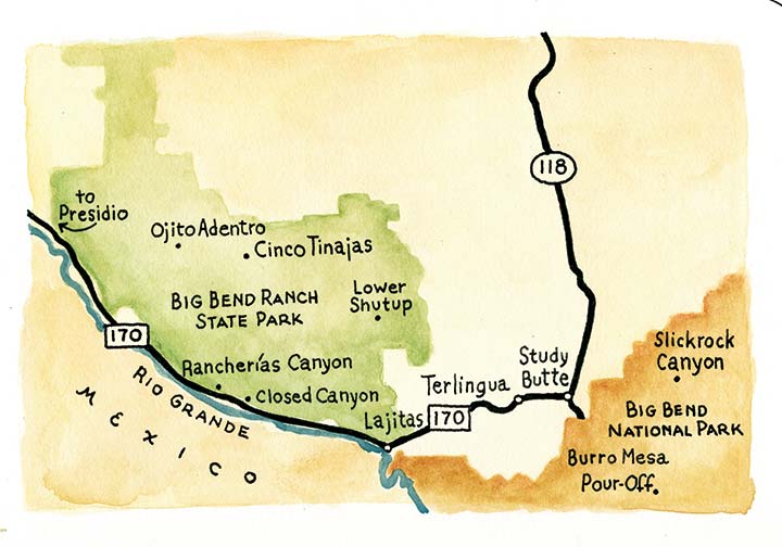
Closed Canyon
![]() Possibly the best-known of the seven, Closed Canyon is easy to find and easy to hike. Drive about 22 miles west of Lajitas on FM 170, the River Road, into Big Benad Ranch State Park. Park at the Closed Canyon Trailhead and head down the path to the looming mouth of the gorge. Over the eons, water has carved a deep chasm through the mesa thata lies between the valley followed by the highway and Colorado Canyon of the Rio Grande. Except for the volcanic rock through which the canyon is carved, you might think you’re in a Utah slot canyon. It’s shady, spectacular, and a bad place to be in a flood.
Possibly the best-known of the seven, Closed Canyon is easy to find and easy to hike. Drive about 22 miles west of Lajitas on FM 170, the River Road, into Big Benad Ranch State Park. Park at the Closed Canyon Trailhead and head down the path to the looming mouth of the gorge. Over the eons, water has carved a deep chasm through the mesa thata lies between the valley followed by the highway and Colorado Canyon of the Rio Grande. Except for the volcanic rock through which the canyon is carved, you might think you’re in a Utah slot canyon. It’s shady, spectacular, and a bad place to be in a flood.
The walking is easy at first on gravel and polished bedrock, but becomes more challenging toward the end. You’ll have to scramble down a few small pour-offs, and after a mere seven-tenths of a mile, your journey ends at a pour-off too high to descend. Listen quietly and you might hear the faint murmur of the Rio Grande, just out of sight down the canyon.
Ojito Adentro
![]() For another easy hike, drive deep into the heart of Big Bend Ranch State Park. Park at the marked trailhead 8.7 miles past the park-entrance kiosk (on Sauceda Ranch Road). Your destination is visible from the parking lot—a mass of lush cottonwood trees tucked into a canyon below Agua Adentro Mountain.
For another easy hike, drive deep into the heart of Big Bend Ranch State Park. Park at the marked trailhead 8.7 miles past the park-entrance kiosk (on Sauceda Ranch Road). Your destination is visible from the parking lot—a mass of lush cottonwood trees tucked into a canyon below Agua Adentro Mountain.
Initially, the trail winds through the desert into the dry wash of Bofecillos Creek. Cross through a gate in a fence and walk the easy path upstream into a line of cottonwoods. Continue upstream on the trail through the riparian woodland. The last 100 yards require some scrambling over, around, and under large boulders that have tumbled down from the narrowing canyon walls. You’ll arrive at a sheer-walled box canyon. Small pools lie at the base of the canyon walls in a grotto. Water trickling down the cliff above feeds thick maidenhair ferns, poison oaks, and grapevines that contrast with the surrounding desert. Be sure to stay on the trail to avoid trampling the delicate vegetation. Enjoy the cool spring area before hiking the seven-tenths of a mile back to your car.
Cinco Tinajas
![]() The Cinco Tinajas hike is also relatively easy, about two miles round trip. Drive into the heart of Big Bend Ranch State Park on Sauceda Ranch Road to the Cinco Tinajas Trailhead, 15.8 miles past the park-entrance kiosk. Although there’s little sign of a canyon, follow the trail north about three-tenths of a mile to a small saddle formation with a trail junction. Continue straight and drop down into broad Leyva Canyon. Turn right where the trail soon hits a dry wash and follow it upstream toward the narrow mouth of Cinco Tinajas. Pools of water lie at the mouth of the canyon and in multiple potholes above. Additional pools and pour-offs will soon stop your forward progress. Massive floods carrying sand, gravel, and rocks have polished the dark volcanic rock that makes up the canyon walls and floor. The canyon drains some eight square miles of land surrounding Sauceda, so don’t come here if rain threatens.
The Cinco Tinajas hike is also relatively easy, about two miles round trip. Drive into the heart of Big Bend Ranch State Park on Sauceda Ranch Road to the Cinco Tinajas Trailhead, 15.8 miles past the park-entrance kiosk. Although there’s little sign of a canyon, follow the trail north about three-tenths of a mile to a small saddle formation with a trail junction. Continue straight and drop down into broad Leyva Canyon. Turn right where the trail soon hits a dry wash and follow it upstream toward the narrow mouth of Cinco Tinajas. Pools of water lie at the mouth of the canyon and in multiple potholes above. Additional pools and pour-offs will soon stop your forward progress. Massive floods carrying sand, gravel, and rocks have polished the dark volcanic rock that makes up the canyon walls and floor. The canyon drains some eight square miles of land surrounding Sauceda, so don’t come here if rain threatens.
Return via the same trail to the junction on the small saddle. Hike the side trail a short distance east to an overlook of the canyon from above (be careful near the edge). The side trail continues past the overlook and drops down into one of the dry washes that feeds into the canyon. Follow the wash back upstream to your vehicle.
Upper Burro Mesa Trail
![]()
![]() Many Big Bend National Park visitors have noticed the Upper Burro Mesa Trail parking area along Ross Maxwell Scenic Drive, but few have stopped, and even fewer have hiked the trail. From the parking area, the trail doesn’t look like much—just a dirt path dropping down into a nondescript grassy valley. However, the 3.6-mile round trip hides a dramatic canyon worthy of the effort.
Many Big Bend National Park visitors have noticed the Upper Burro Mesa Trail parking area along Ross Maxwell Scenic Drive, but few have stopped, and even fewer have hiked the trail. From the parking area, the trail doesn’t look like much—just a dirt path dropping down into a nondescript grassy valley. However, the 3.6-mile round trip hides a dramatic canyon worthy of the effort.
The trail follows the valley west and drops into a small canyon requiring some mild scrambling here and there. The canyon joins a larger canyon in about .75 mile, and then joins an even larger drainage, Javelina Wash, in another quarter-mile. Be sure to note these canyon junctions. Floods wash out rock cairns and other trail markers, and you want to make sure you follow the right canyon upstream when you return.
Soon after Javelina Wash, the canyon narrows and cliffs start to rise. A stone arch marks the north wall of the canyon. Near the end, the canyon contains a pour-off that’s easy to scramble down. You will now be in a very deep and narrow slot, with the sky only a thin strip overhead. Within a few yards, the canyon suddenly ends at a huge pour off. Be careful, one slip and you’re dead.
To visit the pour-off from below, drive farther down the Ross Maxwell Scenic Drive to the Lower Burro Mesa spur road and hike up the easy half-mile trail to the base of the pour-off. Don’t do either of these trails in the rain. Javelina Wash drains a large area of the Chisos Mountains foothills.
Slickrock Canyon
![]()
![]() The trailhead for Slickrock Canyon in the national park is even less prepossessing than that of the Upper Burro Mesa Trail. Drive about 11.8 miles west of Panther Junction to a small parking area on the right just after crossing a bridge over Oak Creek. This hike is eight miles round trip, but the walking is easy, following desert washes the entire way. There is no developed trail nor any signs, so a map, compass or GPS unit, and hiking experience are necessary. Walk to the bridge, scramble down into the big wash, and head downstream. It trends northwest through boring desert flats, but don’t give up.
The trailhead for Slickrock Canyon in the national park is even less prepossessing than that of the Upper Burro Mesa Trail. Drive about 11.8 miles west of Panther Junction to a small parking area on the right just after crossing a bridge over Oak Creek. This hike is eight miles round trip, but the walking is easy, following desert washes the entire way. There is no developed trail nor any signs, so a map, compass or GPS unit, and hiking experience are necessary. Walk to the bridge, scramble down into the big wash, and head downstream. It trends northwest through boring desert flats, but don’t give up.
After awhile you’ll notice a canyon cut into Slickrock Mountain to the north. That’s your destination. Rather than cutting across the brushy flats, continue northwest in the wash even though it will start to seem like you’re passing the canyon. When a decent-sized wash comes in from the right after about 2.5 miles, take it. It will lead you right into the canyon in 1.5 miles.
Once you enter the deep, sheer-walled chasm, the four-mile walk will have been worthwhile. Kick back in the shade, photograph the seasonal pools of water, and relax in a place few Big Bend visitors ever see.
Lower Shutup
![]()
![]()
![]() You have to love the name of this place. Lower Shutup is a major canyon that drains much of the Solitario, the huge eroded dome in Big Bend Ranch State Park. This hike requires a high-clearance 4WD vehicle, good hiking skills, a high fitness level, and a map and compass. For trailhead directions, you’ll need the park map; the route is complicated.
You have to love the name of this place. Lower Shutup is a major canyon that drains much of the Solitario, the huge eroded dome in Big Bend Ranch State Park. This hike requires a high-clearance 4WD vehicle, good hiking skills, a high fitness level, and a map and compass. For trailhead directions, you’ll need the park map; the route is complicated.
From the Lower Shutup Trailhead, follow the wash south. There are no trail markers, so pay attention. You don’t want to get lost on your return.
For the entire hike, you just follow the wash downstream. It starts in a fairly broad valley that narrows into a thousand-foot-deep canyon as it carves its way through the southern wall of the Solitario. The colorful cliffs get higher and more sheer with every advancing step. You will have to scramble down several easy pour-offs and climb left around an impassable one. Look for mountain-lion tracks. I saw fresh ones and heard a kitten crying high above me on my first hike here.
Eventually the cliffs fall away as you get through the Solitario wall. By about four miles, you’re through the canyon. Although the climb is
gradual, it’s uphill all the way back to your vehicle.
Upper Rancherías Canyon
![]()
![]()
![]() Not to be confused with the Rancherías Canyon Trail, this is a small section of the Rancherías Loop Trail (six to eight miles round trip), and the reward is a lush desert oasis. Like Lower Shutup, it requires a high-clearance 4WD vehicle, good hiking skills, a high fitness level, and a map and GPS unit or compass. This is a remote area; be careful. For trailhead directions, you’ll need the state park map; the canyon can be reached from either the Guale Mesa Trailhead or Rancherías Road in the center of the park.
Not to be confused with the Rancherías Canyon Trail, this is a small section of the Rancherías Loop Trail (six to eight miles round trip), and the reward is a lush desert oasis. Like Lower Shutup, it requires a high-clearance 4WD vehicle, good hiking skills, a high fitness level, and a map and GPS unit or compass. This is a remote area; be careful. For trailhead directions, you’ll need the state park map; the canyon can be reached from either the Guale Mesa Trailhead or Rancherías Road in the center of the park.
Follow the Rancherías Loop Trail from either trailhead. The creek starts to flow in a grove of cottonwoods at Rancherías Spring just downstream from where the loop trail crosses the canyon. If you’re adventurous, follow the canyon downstream from the spring. You’ll have to scramble down ledges and over boulders at times. More springs add to the flow as the canyon narrows. Pools, small cascades, and scattered cottonwoods make the hike idyllic in contrast to the harsh desert surroundings. About two miles down the canyon you’ll reach the top of seasonal Rancherías Falls, a good place to turn around. This canyon is delicate. Try to walk on rock and bare dirt rather than trampling the vegetation.