Get out of the office. Flee that marathon meeting. Park your car. Exit the laundry room. Now: Find a bench under a tall, green tree, breathe the fresh air, and enjoy a moment of peace and quiet. Ahhh. Feel better?
Of course you do. Medical doctors and common sense agree that spending even a short amount of time outdoors provides such benefits as stress reduction, creative inspiration, and better health. This applies to adults and children alike, although the latter are less likely to sit on said bench than to run around it and burn some energy, which is a good thing.
Texas is known for its wide-open spaces, those where you see nothing but vast landscape (and perhaps a cow or two) for miles. But it also abounds in urban open spaces—small oases of green (or blue) right in the middle of our busiest cities.
These urban havens offer the chance to take a long hike or short stroll, splash in the water, play with your pets, or just relax and meditate. In addition to welcomed slices of the natural world, some feature added bonuses such as outdoor artworks, museums, and historical attractions. Time for a break!
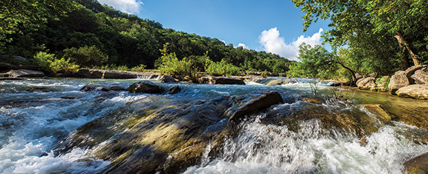
Photo by Michael Amador

Photo by Michael Amador
AUSTIN, Barton Creek Greenbelt
I first fell in love with this ribbon of green through the heart of our capital city on hikes with my young and frisky dog. The Greenbelt takes in 841 acres and a 7.2-mile trail along Barton Creek, a Hill Country landscape of limestone slabs and boulders, shaded tranquil pools, and waterfalls that change dramatically with the seasons and rainfall. I never make the same hike twice here, and whether or not rain has recently fallen, a few spots nearly always have water, at least enough for a doggie drink or a refreshing dip of your feet.
Along the way, Little Barton Creek and Short Spring Creek join in, and the trail winds beneath limestone cliffs, some crawling with rock climbers, and forests of live oak, juniper, Texas persimmon, hackberry, and cedar elm. Native and flowering plants along the way include fragrant mountain laurel, prairie verbena, and Lindheimer silk tassel, to name a few.
Enjoy the company of hikers, many with their dogs, and mountain-bikers (limestone rocks and tree roots make for a bumpy ride), or find a shady spot all to yourself. The Greenbelt also shelters the endangered golden-cheeked warbler, black-capped vireo, and Barton Springs salamander.
The Greenbelt is accessible at various sites along Barton Creek, including at Twin Falls off South MoPac (Loop 1) and from Loop 360. Hikers can also access the Greenbelt near the creek’s confluence with the Colorado River (Lady Bird Lake) in Zilker Park, a 351-acre park that offers the refreshing Barton Springs swimming pool, picnic areas, a playground, sand volleyball courts, a disc golf course, botanical gardens, and the Zilker Zephyr, a miniature train that makes hourly trips along Barton Creek and the shoreline of Lady Bird Lake. Call 512/978-2600.
AMARILLO, Cadillac Ranch
The Texas Panhandle is synonymous with wide-open spaces, but even in its spacious cities one might occasionally feel hemmed in. When folks in Amarillo get a hankering for the wide open, they drive west on Interstate 40, pull off at Exit 60 (Arnot Road), and make a U-turn to the south access road.
Through an always-open gate, they follow a well-worn path to the Cadillac Ranch—the iconic collection of 10 cars buried nose-down in a field at the same angle as the great Cheops pyramid (found in the wide-open spaces of Egypt). A group of San Francisco artists known as The Ant Farm dreamed up this public art installation, aided and abetted by the late Amarillo businessman Stanley Marsh 3. The group buried the Cadillacs in Marsh’s wheat field in 1974, and then moved them in 1997 to another of his fields a few miles west. The cars are arranged in a chronological line, from the 1949 Club Sedan to a 1963 Sedan de Ville.
Thousands of curious visitors continue to apply multiple layers of spray paint to the Caddies (which has always been encouraged); paint now coats every visible surface and probably weighs more than the cars themselves. Bring your own cans or use some left behind by previous graffiti artists.
Don’t expect shade, seating, or any other amenities—just plenty of space to contemplate the quirky installation. If you’re looking for wide-open space in town, check out Amarillo’s Medical Center Park and its trails, playgrounds, fishing ponds, Don Harrington Discovery Center science museum, and Amarillo
Botanical Gardens. Call 800/692-1338.
(Photo by Kevin Stillman)

(Photo by Kevin Stillman)
BEAUMONT, Cattail marsh
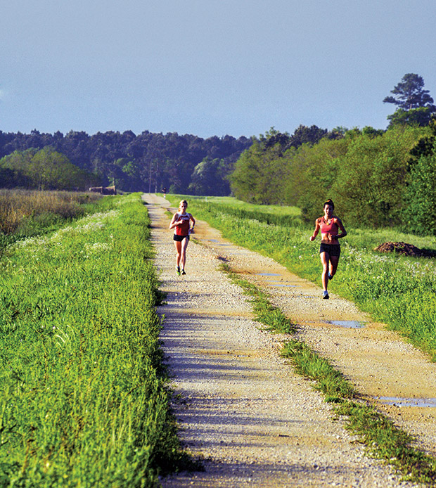
The City of Beaumont Water Utility Department established Cattail Marsh, a 900-acre wildlife refuge, to provide the finishing touches to its water treatment process. The marsh carries out its job simply by functioning as a natural, beautiful wetland—one that’s accessible to the public right in the middle of this East Texas city. Birders have recorded more than 350 species around the site’s eight cattail-fringed ponds, grassy berms, and Hildebrandt Bayou, which runs along the edge of the marsh. Regular spring sightings include pelicans, egrets, roseate spoonbills, ducks, ibises, sandpipers, and red-winged blackbirds. During fall, you may see migrating warblers and hawks. Keep an eye out for the impressive resident alligators, too.
In addition to birding, visitors to Cattail Marsh can enjoy more than eight miles of gravel levee roads for jogging, hiking, biking, horseback riding, wildlife photography, and picnicking. The marsh is located within Tyrrell Park, which also houses the Beaumont Botanical Gardens (home to a native plant center, Japanese garden, rose garden, and fish pond), an 18-hole golf course set among pine trees, a 2.8-mile walking trail, sheltered picnic tables, basketball courts, and a playground area. Call 800/392-4401; .
(Photo by Sean Fitzgerald)

(Photo by Sean Fitzgerald)
DALLAS, Trinity River
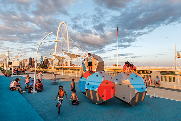
For decades, the stretch of Trinity River near downtown Dallas, channelized in the 1930s to control flooding, represented little more than a barrier between the city and parts west. In the late 1990s, city leaders realized they had an untapped treasure in their midst and formed the Trinity River Corridor Citizens Committee to work with public and private entities to transform 20 miles of river into public parks and green spaces. So far, the transformation includes hiking and biking trails along the levees and shoreline, a set of gnarly kayak rapids near the Santa Fe Trestle trail, and Trinity Overlook Park, a sheltered spot perfect for taking in the impressive Dallas skyline.
Connecting downtown and west Dallas, the Continental Avenue Bridge over the Trinity River has been transformed from a roadway into an elevated park space with an oversize chessboard with two-foot-tall pieces, jets that spray water from the pavement, gardens, and shade canopies. Sitting areas offer views of the spectacular Margaret Hunt Hill Bridge, which now carries the vehicle traffic.
Parking at the West Dallas Gateway provides access to the Continental Avenue Bridge and the 4.6-mile Trinity Skyline Trail, which is also accessible from the Commerce Street Bridge. The Skyline Trail runs on both sides of the river and crosses at the new Sylvan Bridge, which is pedestrian- and bike-friendly and has a boat launch. A section of bike trail just opened in the Design District, and south of downtown, the river transformation continues with the Texas Buckeye Trail, a horse park, the Trinity River Audubon Center, and the Great Trinity Forest, the country’s largest urban forest at roughly 6,000 acres. Ultimately, plans call for the straightened Trinity to wind naturally once again. Call 214/671-9500.
HOUSTON, Discovery Green
An elegant residential neighborhood in the late 19th Century, these 12 acres on the east side of downtown Houston devolved into a series of parking lots by the late 20th. In the early 2000s, several prominent Houstonians looked past all that concrete to envision an urban park, a modern-day village green. Today, Discovery Green is a vibrant 12-acre park, though the word “park” hardly does this urban space justice.
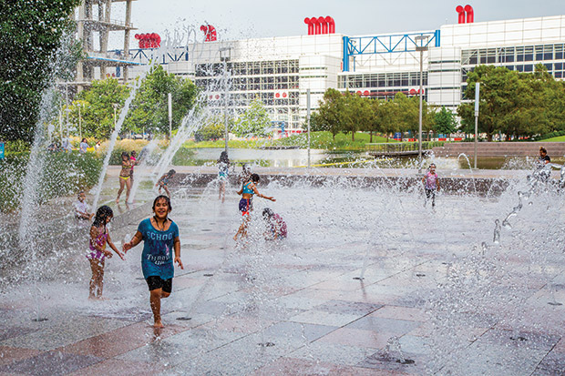
Discovery Green packs in everything from large and small dog runs to putting greens, bocce courts, playgrounds, and the Gateway Fountain—a granite surface with 14-foot water jets to cool off kids of all ages. One-acre Kinder Lake hosts kayaking and paddle-boarding, as well as a model-boat basin; a jogging trail encircles the entire area. Add in lawns, gardens, performance stages, a shady deck, and two restaurants, and you could easily spend an entire day at Discovery Green.
In addition, the Discovery Green Conservancy, the nonprofit that operates the park, hosts some 600 free public events each year, catering to various ages and interests with activities like yoga, parkour, concerts, movies, and flea markets. In winter, part of Kinder Lake transforms into an ice-skating rink, which is no small feat in this coastal Texas city. Come for the activities and entertainment, or just claim a quiet spot and do nothing. No one will mind. Call 713/400-7336.
(Photo by Laurence Parent)

(Photo by Laurence Parent)
EL PASO, Franklin Mountains
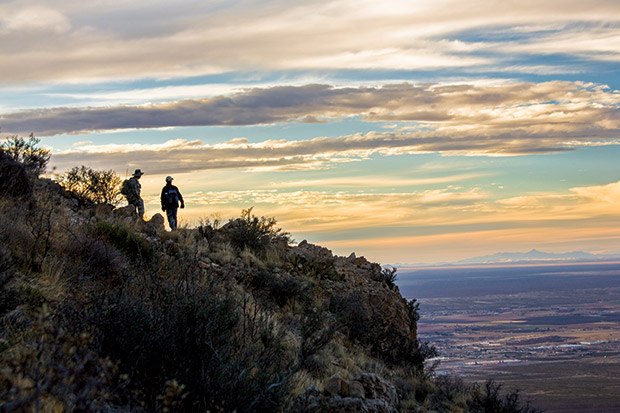
El Paso claims the ultimate urban open space in Franklin Mountains State Park, a mountain range and the nation’s largest urban park at nearly 40 square miles. Its highest point, North Franklin Peak, summits approximately 3,000 feet above the city at 7,192 feet. The mountains form the northern ramparts of the Paso del Norte, or Pass of the North, a route bisecting the U.S.-Mexico border that has been traversed for centuries by Native Americans, soldiers, missionaries, traders, gold prospectors, and other travelers.
Today, this island in an urban sea offers more than 135 miles of trails comprised of 30 to 40 sections; all of the trails are open to hiking and biking (park rangers recommend only about 85 miles for biking). Those looking for relaxation gravitate to the Tom Mays picnic area and scenic overlook; from here you can see the city and desert below, and beyond, the Rio Grande and Mexico. The park’s northern Chihuahuan Desert landscape features dramatic vegetation, such as lechuguilla, sotol, ocotillo, and yuccas; it’s the only Texas location of a number of plants, including the Southwest barrel cactus. Park yourself in the wildlife blind on the three-quarter-mile Nature Trail to watch for deer, fox, badgers, coyotes, and other small mammals; birds like golden eagles, hawks, and owls; and such reptiles as collared lizards and western diamondback rattlesnakes.
The park’s primary entrance points are from McKelligon Road (location of the park headquarters) on the southeast side; from Interstate 10 on the west side; and from US 54 on the east side. Those who want to linger overnight can choose from tent camping sites and five RV sites (no water or electricity). Call 915/566-6441.
LUBBOCK, National Ranching Heritage Center
At Texas Tech University’s National Ranching Heritage Center in Lubbock, travel back in time as well as out-of-doors. The center is home to 48 authentic ranch structures from some of the West’s most well-known ranches, including the XIT in the Panhandle and the Four Sixes in King County. Placed in chronological order in a 19-acre historical park with grassy hills dotted with sotol and mesquite trees, the buildings portray the evolution of ranch life from the late 1700s through the 1950s.
A 1.5-mile walking trail leads visitors past vintage windmills, barns, corrals, a one-room schoolhouse, and the old Santa Fe Railway depot from nearby Ropesville. Ponder life in a cabin built with cactus stalks and mud, a dugout, or a two-story, mail-order ranch home—each restored and outfitted for its time period. Or just enjoy the fresh air from one of many benches along the trail and watch for jackrabbits and birds, such as thrashers and hummingbirds, which are lured here by wildflowers and native prairie grasses.
Located on the edge of the Texas Tech campus, the National Ranching Heritage Center not only offers a respite from the hustle and bustle of modern life, but it also may make you appreciate our modern conveniences a bit more (indoor plumbing and electricity, anyone?). The center also has a six-gallery museum with ranching artifacts and a collection of Western artwork. Hours are 10-5 Monday-Saturday, and 1-5 Sunday (the historical park closes at 4). Free entry. Call 806/742-0498.
SAN ANTONIO, Japanese Tea Garden at Brackenridge Park
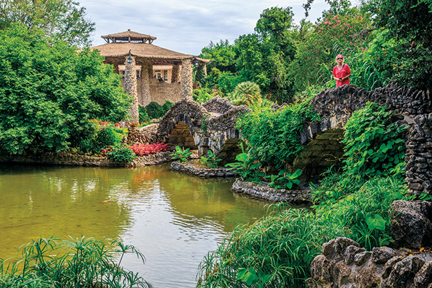
The Japanese Tea Garden at Brackenridge Park began life as a stone quarry in the mid-1800s. Today, the limestone walls of the old quarry enclose shaded walkways, stone bridges, a 60-foot waterfall, lush gardens, and ponds filled with koi fish. The quarry closed in 1908, and in 1917, Ray Lambert, San Antonio’s parks commissioner, began transforming it into a lily pond complete with an island and a Japanese pagoda. Local residents donated lily bulbs, and the city provided plants and a lighting system; palm leaves from trees in city parks formed the pagoda roof.
In 1919, local Japanese-American tea importer Kimi Eizo Jingu and his family moved into a two-story house built with rocks from the quarry next door to the garden to oversee the facility. In 1926, the Jingus opened the Bamboo Room on the second floor of the house, serving light lunches and tea. Facing anti-Japanese sentiment following Pearl Harbor and the start of World War II, the Jingu family left the house in 1942. For several decades, the facility operated as the Chinese Sunken Garden, and in 1984, Jingu’s children and representatives of the Japanese government attended a ceremony as the city rededicated it as the Japanese Tea Garden.
The city and the San Antonio Parks Foundation began a major restoration in 2006, transforming the Jingu home into a café. Today, it serves lunch and a selection of Japanese teas—hot or cold (this is Texas, after all). Out in the garden, the large, open-air pagoda surveys a series of koi ponds, the waterfall, and gardens. A short walk from Brackenridge Park and the San Antonio Zoo, this unique urban space offers a quiet (and free) retreat every day from sunrise to sunset.
Heiwa, y’all. Call 210/212-8423.
CORPUS CHRISTI, McGee Beach Park, North Beach
Nothing feels wide open quite like the sea. And for the lucky Texans who reside in coastal cities, the comfort and peace of those maritime vistas are right in town. Most of Corpus Christi, for example, faces the water. Those seeking a little open space can pop into one of a series of parks along the city’s shoreline.
One particularly inviting spot, McGee Beach on Shoreline Boulevard near downtown, offers a wide, sandy beach. The sand backs up to a stair-stepped seawall that’s a perfect place to sit and watch the gentle, white-capped waves roll ashore, one after the other. Gulls hover overhead, their raucous calls like hysterical laughter, and out over the waves, pelicans circle before crashing headfirst into the water, emerging unscathed a few seconds later.
Across the Harbor Bridge on Texas 35 north of downtown lies North Beach. This long, narrow strip of sand sports picnic tables and a few clusters of palm trees that rustle in the constant sea breeze. From a shady spot beneath one of said palms, beach-goers watch kite surfers zipping along the water’s surface at seemingly superhuman speeds and, in the distance, large ships making their way to and from the Corpus Christi port.
Both of these car-free beach parks have free parking and public restrooms and are close to restaurants and other attractions such as the Corpus Christi Marina, the Art Museum of South Texas, Texas State Aquarium, and USS Lexington. Call 800/678-6232; visitcorpuschristitx.org/see-and-do/beaches.
